IMAGES TAKEN NEAR TO
Riverside Walk, MELTON MOWBRAY, LE14 3SD
Introduction
This page details the photographs taken nearby to Riverside Walk, LE14 3SD by members of the Geograph project.
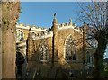
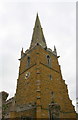
The Geograph project started in 2005 with the aim of publishing, organising and preserving representative images for every square kilometre of Great Britain, Ireland and the Isle of Man.

There are currently over 7.5m images from over14,400 individuals and you can help contribute to the project by visiting https://www.geograph.org.uk
Image Map
Images are licensed for reuse under creativecommons.org/licenses/by-sa/2.0
Notes
- Clicking on the map will re-center to the selected point.
- The higher the marker number, the further away the image location is from the centre of the postcode.
Image Listing (52 Images Found)
Images are licensed for reuse under creativecommons.org/licenses/by-sa/2.0
Image
Details
Distance
1
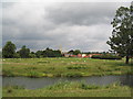
View across the Wreake to Asfordby
Looking to the Church of All Saints
Image: © Tim Heaton
Taken: 12 Aug 2007
0.02 miles
2
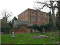
The Old Rectory, Asfordby
Dates from the late eighteenth century and subsequently altered https://historicengland.org.uk/listing/the-list/list-entry/1295102?section=official-list-entry
Image: © Jonathan Thacker
Taken: 26 Dec 2023
0.04 miles
3
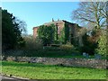
The Old Rectory, Asfordby
A fine square-plan Georgian house of the late 18th century, not looking at its best from this side with extensive growth of ivy. Thought to have been built by Thomas Burnaby who was rector from 1777. Listed Grade II*.
Image: © Alan Murray-Rust
Taken: 25 Nov 2016
0.04 miles
4
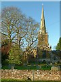
Church of All Saints, Asfordby
View across the churchyard from the east. The church is classic ironstone, largely 14th century, with 15th century spire. Listed Grade I.
Image: © Alan Murray-Rust
Taken: 25 Nov 2016
0.04 miles
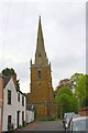
5
Church of All Saints, Asfordby
The south transept. The presence of an aisle to the transept is an unusual feature for a relatively small village church. 14th century Decorated reticulated tracery in the main window.
Image: © Alan Murray-Rust
Taken: 25 Nov 2016
0.05 miles
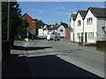
8
All Saints Church at the end of the road
Image: © Roger Templeman
Taken: 7 May 2017
0.06 miles
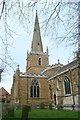
9
The spire on top of the tower of All Saints Church
The spire is an Ordnance Survey intersected station trig point, see http://trigpointing.uk/trig/10711
Image: © Roger Templeman
Taken: 7 May 2017
0.06 miles
10
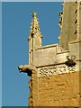
Church of All Saints, Asfordby
Detail of the 15th century tower parapet with panelled frieze and gargoyles.
Image: © Alan Murray-Rust
Taken: 25 Nov 2016
0.06 miles