IMAGES TAKEN NEAR TO
St. Johns Road, MELTON MOWBRAY, LE14 3QY
Introduction
This page details the photographs taken nearby to St. Johns Road, LE14 3QY by members of the Geograph project.
The Geograph project started in 2005 with the aim of publishing, organising and preserving representative images for every square kilometre of Great Britain, Ireland and the Isle of Man.

There are currently over 7.5m images from over14,400 individuals and you can help contribute to the project by visiting https://www.geograph.org.uk
Image Map
Images are licensed for reuse under creativecommons.org/licenses/by-sa/2.0
Notes
- Clicking on the map will re-center to the selected point.
- The higher the marker number, the further away the image location is from the centre of the postcode.
Image Listing (18 Images Found)
Images are licensed for reuse under creativecommons.org/licenses/by-sa/2.0
Image
Details
Distance
1
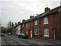
South Street, Asfordby Hill
Built in association with local iron works.
Image: © Jonathan Thacker
Taken: 21 Dec 2021
0.06 miles
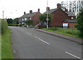
2
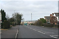
Melton Road, Asfordby Hill
This village occupies a commanding position at the top of the hill.
Image: © Kate Jewell
Taken: 26 Mar 2006
0.07 miles
3
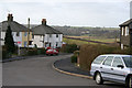
Crompton Road, Asfordby Hill
Looking south towards Ab Kettleby, Compton Road ends at the grid square boundary.
Image: © Kate Jewell
Taken: 26 Mar 2006
0.07 miles
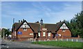
4
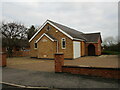
Former Methodist church, Asfordby Hill
Bears a date stone of 1959. Now a house.
Image: © Jonathan Thacker
Taken: 21 Dec 2021
0.07 miles
5
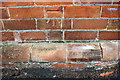
Benchmark on #23 Welbey Road
Ordnance Survey cut mark benchmark described on the Bench Mark Database at www.bench-marks.org.uk/bm84939
Image: © Roger Templeman
Taken: 7 May 2017
0.08 miles
6
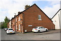
Houses of Welby Road at South Street junction
There is an OS benchmark Image on the front of the nearest house
Image: © Roger Templeman
Taken: 7 May 2017
0.08 miles
9
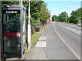
Phone box in Asfordby Hill
On Melton Road, opposite the junction with Crompton Road.
Image: © Mat Fascione
Taken: 30 Jun 2012
0.13 miles
10
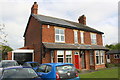
Nos. 65 and 67 Welby Road (Welby Villas)
There is an Ordnance Survey cut mark benchmark (see www.bench-marks.org.uk/bm84938) on the side of the left hand house at its front corner
Image: © Roger Templeman
Taken: 7 May 2017
0.13 miles