IMAGES TAKEN NEAR TO
Dukes Road, MELTON MOWBRAY, LE14 3LG
Introduction
This page details the photographs taken nearby to Dukes Road, LE14 3LG by members of the Geograph project.
The Geograph project started in 2005 with the aim of publishing, organising and preserving representative images for every square kilometre of Great Britain, Ireland and the Isle of Man.

There are currently over 7.5m images from over14,400 individuals and you can help contribute to the project by visiting https://www.geograph.org.uk
Image Map
Images are licensed for reuse under creativecommons.org/licenses/by-sa/2.0
Notes
- Clicking on the map will re-center to the selected point.
- The higher the marker number, the further away the image location is from the centre of the postcode.
Image Listing (4 Images Found)
Images are licensed for reuse under creativecommons.org/licenses/by-sa/2.0
Image
Details
Distance
1
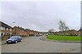
Queensway, Queensway Old Dalby
The name originating from the Queen's 1953 coronation, when the MOD started to build houses on its REME Old Dalby base.
Image: © Tim Heaton
Taken: 19 Feb 2021
0.18 miles
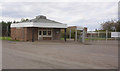
3
The rear of the Belvoir Brewery
This is the working part. Inside is a craft brewery, using equipment recovered from traditional cask ale breweries all over the country. The ales produced (and very nice they are!) may be sampled in the bar at the front of the building, and tours of the working brewery are held.
Image: © Richard Green
Taken: 31 Aug 2013
0.22 miles
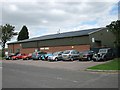
4
Belvoir Brewery, Old Dalby
The front of the building is a traditional pub bar with handpumps serving the range of Belvoir Brewery ales brewed on the premises. It incorporates a restaurant serving very good quality food, and there is seating outside for warm weather.
Image: © Richard Green
Taken: 31 Aug 2013
0.22 miles