IMAGES TAKEN NEAR TO
Welby Road, MELTON MOWBRAY, LE14 3JL
Introduction
This page details the photographs taken nearby to Welby Road, LE14 3JL by members of the Geograph project.
The Geograph project started in 2005 with the aim of publishing, organising and preserving representative images for every square kilometre of Great Britain, Ireland and the Isle of Man.

There are currently over 7.5m images from over14,400 individuals and you can help contribute to the project by visiting https://www.geograph.org.uk
Image Map
Images are licensed for reuse under creativecommons.org/licenses/by-sa/2.0
Notes
- Clicking on the map will re-center to the selected point.
- The higher the marker number, the further away the image location is from the centre of the postcode.
Image Listing (19 Images Found)
Images are licensed for reuse under creativecommons.org/licenses/by-sa/2.0
Image
Details
Distance
1
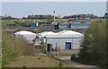
Asfordby Business Park/Holwell iron works
Image: © Andrew Tatlow
Taken: 10 Apr 2020
0.09 miles
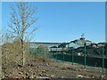
3
Holwell Industrial Site
The Holwell Ironworks are a shade of their former self and the ill fated Vale of Belvoir/Asfordby coal mine is history; large site is now becoming an industrial estate. The ironworks were taken over by the French company SAINT-GERMAN and some pipe production continues on the site.
Image: © Andrew Tatlow
Taken: 10 Apr 2020
0.14 miles
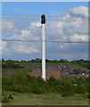
4
Holwell Works, slag tip
A reminder that this was an important iron-smelting site, this is correctly a slag tip, rather than a spoil tip.
Image: © Alan Murray-Rust
Taken: 25 Nov 2016
0.16 miles
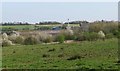
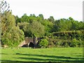
5

Entrance to Asfordby Business Park
The business park was developed on the site of the abortive Asfordby coal mine.
Image: © Alan Murray-Rust
Taken: 25 Nov 2016
0.19 miles
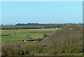
6
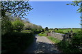
Welby Lane crossing a tributary to Welby Brook
Image: © Tim Heaton
Taken: 24 Apr 2020
0.20 miles
8
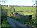
Bridge on Welby Lane
This carries the lane over the Holwell Brook (the brick parapet) and the former Holwell Mineral Railway (the iron parapet beyond). See also http://www.geograph.org.uk/photo/3350068
The sloping field in the background contains remnants of the medieval village of Welby.
There is a bench mark http://www.geograph.org.uk/photo/5208777 on the near end of the parapet.
Image: © Alan Murray-Rust
Taken: 25 Nov 2016
0.21 miles
9
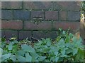
Bench mark, Welby Lane bridge
See http://www.geograph.org.uk/photo/5208774 for location.
Image: © Alan Murray-Rust
Taken: 25 Nov 2016
0.21 miles
10
Holwell Works
Still producing cast iron drainage products although much reduced in extent from its heyday. Set up in the late 19th century by the Holwell Iron and Coal company to exploit its ironstone workings, it later became part of Stanton and Staveley and is now part of the French St Gobain group.
Image: © Alan Murray-Rust
Taken: 25 Nov 2016
0.21 miles