IMAGES TAKEN NEAR TO
Quorn Avenue, MELTON MOWBRAY, LE14 3JF
Introduction
This page details the photographs taken nearby to Quorn Avenue, LE14 3JF by members of the Geograph project.
The Geograph project started in 2005 with the aim of publishing, organising and preserving representative images for every square kilometre of Great Britain, Ireland and the Isle of Man.

There are currently over 7.5m images from over14,400 individuals and you can help contribute to the project by visiting https://www.geograph.org.uk
Image Map
Images are licensed for reuse under creativecommons.org/licenses/by-sa/2.0
Notes
- Clicking on the map will re-center to the selected point.
- The higher the marker number, the further away the image location is from the centre of the postcode.
Image Listing (59 Images Found)
Images are licensed for reuse under creativecommons.org/licenses/by-sa/2.0
Image
Details
Distance
2
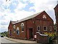
Wesleyan Chapel, Ab Kettleby
Founded 1845, with a Sunday School attached to the far end in 1898.
Image: © Tim Heaton
Taken: 30 Jul 2006
0.08 miles
3
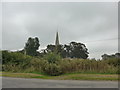
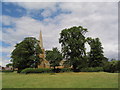
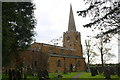
Looking from Chapel Lane towards St James
Image: © Basher Eyre
Taken: 15 Sep 2014
0.09 miles
4
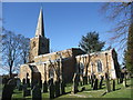
Church of St James the Greater, Ab Kettleby
Structural problems and falling plaster resulted in the church being closed in 2006, and it is now on the English Heritage national buildings 'at risk' list. It is hoped that a major local fundraising campaign, and Lottery support, will lead to restoration.
Image: © Tim Heaton
Taken: 19 Feb 2012
0.09 miles
5
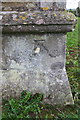
Benchmark on tower buttress of St James's Church
Ordnance Survey cut mark benchmark described on the Bench Mark Database at http://www.bench-marks.org.uk/bm71024
Image: © Roger Templeman
Taken: 2 May 2016
0.09 miles
6
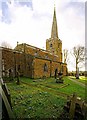
Church of St James the Greater, Ab Kettleby
With the leaves off the trees, this is about as good a view of the complete church as it is possible to get. 13th century with 14th century upper stage to tower and spire. Listed Grade II*.
Image: © Alan Murray-Rust
Taken: 25 Nov 2016
0.09 miles
7
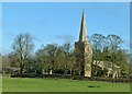
Church of St James, Ab Kettleby
Standing on an open site to the south of the village. Though, like so many churches, somewhat obscured by large trees.
Image: © Tim Heaton
Taken: 30 Jul 2006
0.09 miles
10
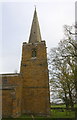
Tower and spire of St James's Church
There is an OS benchmark Image on the buttress on the right hand corner of the tower. The spire is an OS intersected station trig point, http://trigpointing.uk/trig/13909
Image: © Roger Templeman
Taken: 2 May 2016
0.10 miles