IMAGES TAKEN NEAR TO
Nottingham Road, MELTON MOWBRAY, LE14 3JB
Introduction
This page details the photographs taken nearby to Nottingham Road, LE14 3JB by members of the Geograph project.
The Geograph project started in 2005 with the aim of publishing, organising and preserving representative images for every square kilometre of Great Britain, Ireland and the Isle of Man.

There are currently over 7.5m images from over14,400 individuals and you can help contribute to the project by visiting https://www.geograph.org.uk
Image Map
Images are licensed for reuse under creativecommons.org/licenses/by-sa/2.0
Notes
- Clicking on the map will re-center to the selected point.
- The higher the marker number, the further away the image location is from the centre of the postcode.
Image Listing (30 Images Found)
Images are licensed for reuse under creativecommons.org/licenses/by-sa/2.0
Image
Details
Distance
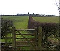
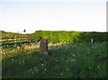
3
Old enclosed reservoir at Ab Kettleby
The Broughton Hill triangulation pillar is in the foreground.
Image: © Andrew Tatlow
Taken: 2 Apr 2020
0.13 miles
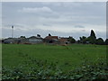
4
Ab Kettleby Service Reservoir
Along Clawson Lane.
Image: © Mat Fascione
Taken: 20 Jul 2008
0.13 miles
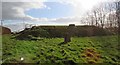
5
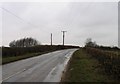
Clawson Lane
The Ab Kettleby water storage reservoir is to the left of the road.
Image: © Andrew Tatlow
Taken: 26 Feb 2010
0.13 miles
7
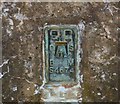
Plate on Broughton Hill triangulation pillar
Image: © Andrew Tatlow
Taken: 22 May 2010
0.13 miles
8
Top of Broughton Hill triangulation pillar
Image: © Andrew Tatlow
Taken: 2 Apr 2020
0.14 miles
9
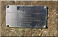
Plate on Broughton Hill triangulation pillar
Image: © Andrew Tatlow
Taken: 2 Apr 2020
0.14 miles
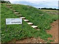
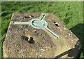
10
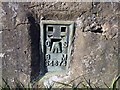
Flush bracket on Broughton Hill triangulation pillar
Flush bracket S4674.
Image: © Andrew Tatlow
Taken: 2 Apr 2020
0.14 miles