IMAGES TAKEN NEAR TO
Clawson Lane, MELTON MOWBRAY, LE14 3HX
Introduction
This page details the photographs taken nearby to Clawson Lane, LE14 3HX by members of the Geograph project.
The Geograph project started in 2005 with the aim of publishing, organising and preserving representative images for every square kilometre of Great Britain, Ireland and the Isle of Man.

There are currently over 7.5m images from over14,400 individuals and you can help contribute to the project by visiting https://www.geograph.org.uk
Image Map
Images are licensed for reuse under creativecommons.org/licenses/by-sa/2.0
Notes
- Clicking on the map will re-center to the selected point.
- The higher the marker number, the further away the image location is from the centre of the postcode.
Image Listing (37 Images Found)
Images are licensed for reuse under creativecommons.org/licenses/by-sa/2.0
Image
Details
Distance
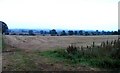
1
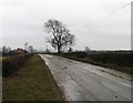
Towards Ab Kettleby
This is one of the high points in Leicestershire and there should be a view towards Melton Mowbray and the Wreake Valley.
Image: © Andrew Tatlow
Taken: 26 Feb 2010
0.05 miles
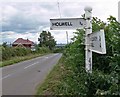
2
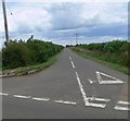
Nursery Lane towards Holwell
At its junction with Clawson Lane.
Image: © Mat Fascione
Taken: 20 Jul 2008
0.10 miles
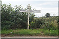
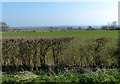
6
View towards Melton Mowbray
A very damp evening in Leicestershire.
Image: © Andrew Tatlow
Taken: 6 Sep 2010
0.11 miles
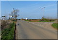
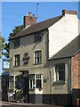
8
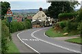
The Sugar Loaf, Ab Kettleby
A public house along the A606 Nottingham Road.
Image: © Mat Fascione
Taken: 20 Jul 2008
0.16 miles
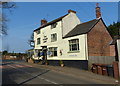
9
Ab Kettleby Sugar Loaf Pub
Village pub on the main Melton to Nottingham road (A606)
Image: © the bitterman
Taken: 10 Oct 2010
0.17 miles
10
The Sugar Loaf in Ab Kettleby
Public house along Nottingham Road.
Image: © Mat Fascione
Taken: 29 Mar 2014
0.17 miles