IMAGES TAKEN NEAR TO
Melton Road, MELTON MOWBRAY, LE14 3ES
Introduction
This page details the photographs taken nearby to Melton Road, LE14 3ES by members of the Geograph project.
The Geograph project started in 2005 with the aim of publishing, organising and preserving representative images for every square kilometre of Great Britain, Ireland and the Isle of Man.

There are currently over 7.5m images from over14,400 individuals and you can help contribute to the project by visiting https://www.geograph.org.uk
Image Map
Images are licensed for reuse under creativecommons.org/licenses/by-sa/2.0
Notes
- Clicking on the map will re-center to the selected point.
- The higher the marker number, the further away the image location is from the centre of the postcode.
Image Listing (11 Images Found)
Images are licensed for reuse under creativecommons.org/licenses/by-sa/2.0
Image
Details
Distance
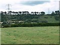
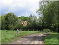
2
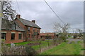
Bridleway at Bouverie Lodge
Bed and Breakfast on a bison farm https://www.bisons.org/
Image: © Tim Heaton
Taken: 19 Feb 2021
0.08 miles
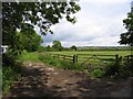
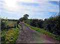
3
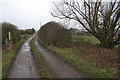
Broughton Lodges near Nether Broughton
Looking west along a farm track towards Broughton Lodges, a couple of farms and a few houses.
Image: © Kate Jewell
Taken: 8 Mar 2006
0.08 miles