IMAGES TAKEN NEAR TO
Chapel Lane, MELTON MOWBRAY, LE14 3EN
Introduction
This page details the photographs taken nearby to Chapel Lane, LE14 3EN by members of the Geograph project.
The Geograph project started in 2005 with the aim of publishing, organising and preserving representative images for every square kilometre of Great Britain, Ireland and the Isle of Man.

There are currently over 7.5m images from over14,400 individuals and you can help contribute to the project by visiting https://www.geograph.org.uk
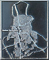
Image Map
Images are licensed for reuse under creativecommons.org/licenses/by-sa/2.0
Notes
- Clicking on the map will re-center to the selected point.
- The higher the marker number, the further away the image location is from the centre of the postcode.
Image Listing (64 Images Found)
Images are licensed for reuse under creativecommons.org/licenses/by-sa/2.0
Image
Details
Distance
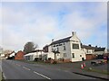
1
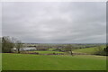
View over the Vale of Belvoir from Green hill
The edge of the Crown Park business estate on the left, and the village of Nether Broughton on the right horizon.
Image: © Tim Heaton
Taken: 19 Feb 2021
0.03 miles
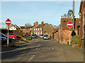
2
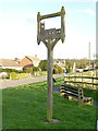
Nether Broughton village sign, Middle Lane
The sign shows a silhouette of the village church. The top bar is inscribed Broctone, the medieval name of the village.
Image: © Alan Murray-Rust
Taken: 11 Apr 2015
0.03 miles
3
Medieval strip fields, Nether Broughton
Panel from one of the several heritage trail information boards around the village.
Image: © Alan Murray-Rust
Taken: 11 Apr 2015
0.03 miles
4
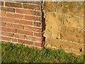
Bench mark, Moat Farm Nether Broughton
See http://www.geograph.org.uk/photo/4430928 for location.
Image: © Alan Murray-Rust
Taken: 11 Apr 2015
0.04 miles
5
Moat Farm, Nether Broughton
There is a bench mark http://www.geograph.org.uk/photo/4430931 on the gable end.
Image: © Alan Murray-Rust
Taken: 11 Apr 2015
0.05 miles
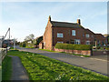
6
Chapel Lane, Nether Broughton
This forms a one-way circuit with Heckadeck Lane, principally to eliminate the awkward exit from Heckadeck Lane onto the main A606.
Image: © Alan Murray-Rust
Taken: 11 Apr 2015
0.05 miles
7
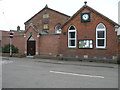
Chapel now Hall
The former Wesleyan Chapel in Nether Broughton is now the village hall. The clock was either bang on time or had stopped at the exact time of the photograph.
Image: © Michael Patterson
Taken: 25 Apr 2006
0.06 miles
8
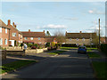
Parnham's Close, Nether Broughton
1950s development of council houses. The house directly at the end is a prefabricated 'Airey' house, but all the rest are in traditional brick.
The close takes its name from the field on which it was built, probably named after Mary Parnham who died in 1721 and left a substantial legacy to purchase land, the rents from which were used to assist the poor of the parish.
Image: © Alan Murray-Rust
Taken: 11 Apr 2015
0.06 miles
10
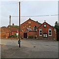
Nether Broughton Village Hall
A former Wesleyan Chapel, built in 1839 and renovated in 1889 according to the date stones.
Image: © John Sutton
Taken: 20 Jun 2017
0.07 miles