IMAGES TAKEN NEAR TO
Clawson Lane, MELTON MOWBRAY, LE14 3AB
Introduction
This page details the photographs taken nearby to Clawson Lane, LE14 3AB by members of the Geograph project.
The Geograph project started in 2005 with the aim of publishing, organising and preserving representative images for every square kilometre of Great Britain, Ireland and the Isle of Man.

There are currently over 7.5m images from over14,400 individuals and you can help contribute to the project by visiting https://www.geograph.org.uk
Image Map
Images are licensed for reuse under creativecommons.org/licenses/by-sa/2.0
Notes
- Clicking on the map will re-center to the selected point.
- The higher the marker number, the further away the image location is from the centre of the postcode.
Image Listing (115 Images Found)
Images are licensed for reuse under creativecommons.org/licenses/by-sa/2.0
Image
Details
Distance
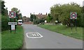
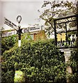
2
Clawson Lane towards Hickling
The high ground in the distance is known as Hickling Standard.
Image: © Mat Fascione
Taken: 30 Aug 2008
0.04 miles
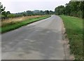
3
Chestnut House
For a description see http://www.britishlistedbuildings.co.uk/en-425589-chestnut-house-hickling
Image: © Jonathan Thacker
Taken: 10 Mar 2012
0.11 miles
4

The Cottage and Little Cottage, Main Street
Early 19th century brick cottages, clearly recently renovated. Listed Grade II.
Image: © Alan Murray-Rust
Taken: 30 Mar 2015
0.11 miles
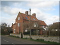
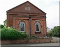
5

Chestnut House, Main Street
The original, taller, part of the house is early 18th century, with additions from the 19th century. Listed Grade II.
Image: © Alan Murray-Rust
Taken: 30 Mar 2015
0.11 miles
6
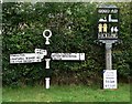
Signposts in Hickling
At the junction of Main Street and Bridegate Lane.
Image: © Mat Fascione
Taken: 30 Aug 2008
0.12 miles
7
Direction Sign ? Signpost
Located on the east side of the T junction of Main Street and Bridgegate Lane in Hickling parish. 3 arms and annulus finial. See also https://www.geograph.org.uk/photo/4407303 and https://www.geograph.org.uk/photo/944587.
Milestone Society National ID: NT_SK6929
Image: © I Craddock
Taken: 14 Aug 2020
0.13 miles
9
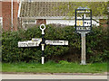
Fingerpost, Main Street/Bridegate Lane, Hickling
Traditional Notts CC cast iron fingerpost with annular finial. A careful look shows that a number of the attached letters are replacements in different style, and that the right hand arm points to 'Nether Brou9hton'. Presumably they had run out of 'G's and used a '9' as the nearest shape.
Image: © Alan Murray-Rust
Taken: 30 Mar 2015
0.13 miles
10
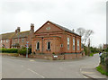
Former Wesleyan Methodist Chapel
Now a private house. Dated 1848 in the gable.
Image: © Alan Murray-Rust
Taken: 30 Mar 2015
0.14 miles