IMAGES TAKEN NEAR TO
Whissendine Road, MELTON MOWBRAY, LE14 2XJ
Introduction
This page details the photographs taken nearby to Whissendine Road, LE14 2XJ by members of the Geograph project.
The Geograph project started in 2005 with the aim of publishing, organising and preserving representative images for every square kilometre of Great Britain, Ireland and the Isle of Man.

There are currently over 7.5m images from over14,400 individuals and you can help contribute to the project by visiting https://www.geograph.org.uk
Image Map
Images are licensed for reuse under creativecommons.org/licenses/by-sa/2.0
Notes
- Clicking on the map will re-center to the selected point.
- The higher the marker number, the further away the image location is from the centre of the postcode.
Image Listing (7 Images Found)
Images are licensed for reuse under creativecommons.org/licenses/by-sa/2.0
Image
Details
Distance
2
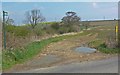
Footpath to Jericho Lodge
Looking northeast from Whissendine Road.
Image: © Mat Fascione
Taken: 21 Apr 2008
0.07 miles
3
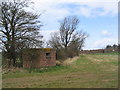
Pill box near Bickfield Farm
On low ground, at least 1000 metres from the Melton Mowbray to Oakham road, it's difficult to imagine what this was defending.
Image: © Tim Heaton
Taken: 17 Apr 2006
0.10 miles
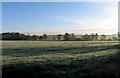
4
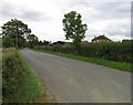
Whissendine Road towards Melton Mowbray
Image: © Andrew Tatlow
Taken: 17 Sep 2010
0.12 miles
5
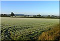
View towards Little Dalby
The first frosty morning seen this season! The spire of St James Little Dalby Image is just to the right of the prominent tree to the left.
Image: © Andrew Tatlow
Taken: 17 Oct 2010
0.19 miles
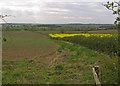
7
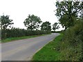
Fields by Whissendine Road
This is a view towards Hose Hill.
Image: © Andrew Tatlow
Taken: 17 Oct 2010
0.20 miles