IMAGES TAKEN NEAR TO
Sawgate Lane, MELTON MOWBRAY, LE14 2XF
Introduction
This page details the photographs taken nearby to Sawgate Lane, LE14 2XF by members of the Geograph project.
The Geograph project started in 2005 with the aim of publishing, organising and preserving representative images for every square kilometre of Great Britain, Ireland and the Isle of Man.

There are currently over 7.5m images from over14,400 individuals and you can help contribute to the project by visiting https://www.geograph.org.uk
Image Map
Images are licensed for reuse under creativecommons.org/licenses/by-sa/2.0
Notes
- Clicking on the map will re-center to the selected point.
- The higher the marker number, the further away the image location is from the centre of the postcode.
Image Listing (14 Images Found)
Images are licensed for reuse under creativecommons.org/licenses/by-sa/2.0
Image
Details
Distance
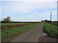
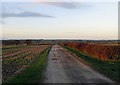
1
Track to Stapleford Lodge
Looking north from Sawgate Road.
Image: © Mat Fascione
Taken: 21 Apr 2008
0.01 miles
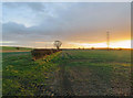
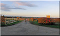
2
Roadway to Stapleford Lodge
The roadway is also a public footpath.
Image: © Jonathan Thacker
Taken: 30 Jun 2021
0.02 miles
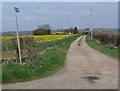
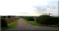
4
Entrance to Sawgate Farm in February 2016
Image: © Andrew Tatlow
Taken: 2 Feb 2016
0.10 miles
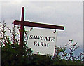
5
Entrance to Sawgate Farm in August 2008
Image: © Andrew Tatlow
Taken: 13 Aug 2008
0.11 miles

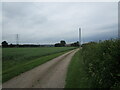
8
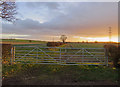
Gateway to field south of Sawgate Road
Image: © Andrew Tatlow
Taken: 2 Feb 2016
0.12 miles