IMAGES TAKEN NEAR TO
Pasture Lane, MELTON MOWBRAY, LE14 2TT
Introduction
This page details the photographs taken nearby to Pasture Lane, LE14 2TT by members of the Geograph project.
The Geograph project started in 2005 with the aim of publishing, organising and preserving representative images for every square kilometre of Great Britain, Ireland and the Isle of Man.

There are currently over 7.5m images from over14,400 individuals and you can help contribute to the project by visiting https://www.geograph.org.uk
Image Map
Images are licensed for reuse under creativecommons.org/licenses/by-sa/2.0
Notes
- Clicking on the map will re-center to the selected point.
- The higher the marker number, the further away the image location is from the centre of the postcode.
Image Listing (26 Images Found)
Images are licensed for reuse under creativecommons.org/licenses/by-sa/2.0
Image
Details
Distance
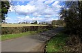
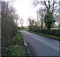
1
Pasture Lane and Ashby Pastures Cottages
Image: © Jonathan Thacker
Taken: 8 Dec 2022
0.01 miles
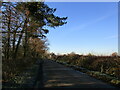
3
Five-barred double gate
On Pasture Lane east of Ashby Pastures Farm.
Image: © Alan Murray-Rust
Taken: 23 May 2018
0.11 miles
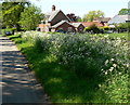
8
Pasture Lane North/Pasture Lane junction
Pasture Lane is straight on and to the left.
Image: © Andrew Tatlow
Taken: 26 Jan 2012
0.19 miles
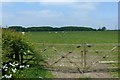
9
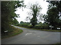
Pasture Lane meets Pasture Lane North
The road from Thorpe Satchville meets the road running from Kirby Bellars (right) to Gaddesby (left)
Image: © Tim Heaton
Taken: 7 Oct 2007
0.19 miles