IMAGES TAKEN NEAR TO
Kirby Lane, MELTON MOWBRAY, LE14 2TS
Introduction
This page details the photographs taken nearby to Kirby Lane, LE14 2TS by members of the Geograph project.
The Geograph project started in 2005 with the aim of publishing, organising and preserving representative images for every square kilometre of Great Britain, Ireland and the Isle of Man.

There are currently over 7.5m images from over14,400 individuals and you can help contribute to the project by visiting https://www.geograph.org.uk
Image Map
Images are licensed for reuse under creativecommons.org/licenses/by-sa/2.0
Notes
- Clicking on the map will re-center to the selected point.
- The higher the marker number, the further away the image location is from the centre of the postcode.
Image Listing (13 Images Found)
Images are licensed for reuse under creativecommons.org/licenses/by-sa/2.0
Image
Details
Distance
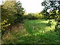
7
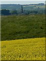
Field off Kirby Lane
Part of Melton Mowbray is visible in the background. Compare with Image
Image: © Andrew Tatlow
Taken: 9 May 2012
0.11 miles
8
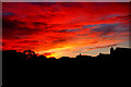
Sunset over Melton Mowbray
Taken on the 5th November 2006 from bedroom window using a tripod. Nikon D50
Image: © gary radford
Taken: 5 Nov 2006
0.12 miles
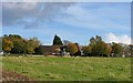
9
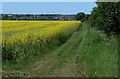
Farmland near Kirby Lane
Looking towards St Peter's Church in the village of Kirby Bellars.
Image: © Mat Fascione
Taken: 1 Jun 2009
0.12 miles
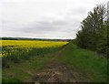
10
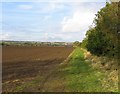
Field off Kirby Lane
Part of Melton Mowbray is visible in the background.
Image: © Andrew Tatlow
Taken: 24 Oct 2010
0.13 miles