IMAGES TAKEN NEAR TO
Main Street, MELTON MOWBRAY, LE14 2QT
Introduction
This page details the photographs taken nearby to Main Street, LE14 2QT by members of the Geograph project.
The Geograph project started in 2005 with the aim of publishing, organising and preserving representative images for every square kilometre of Great Britain, Ireland and the Isle of Man.

There are currently over 7.5m images from over14,400 individuals and you can help contribute to the project by visiting https://www.geograph.org.uk
Image Map
Images are licensed for reuse under creativecommons.org/licenses/by-sa/2.0
Notes
- Clicking on the map will re-center to the selected point.
- The higher the marker number, the further away the image location is from the centre of the postcode.
Image Listing (33 Images Found)
Images are licensed for reuse under creativecommons.org/licenses/by-sa/2.0
Image
Details
Distance
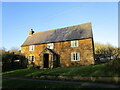


6
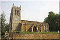
Trees and All Saints' church, Pickwell
Image: © Jonathan Thacker
Taken: 2 Dec 2021
0.08 miles
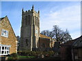
7
All Saints Church
There is an OS benchmark Image on the front face of the buttress on the left hand side of the tower
Image: © Roger Templeman
Taken: 21 Apr 2014
0.09 miles
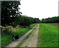
8
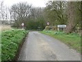
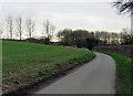
Approaching Pickwell along Stygate Lane
Image: © Mat Fascione
Taken: 21 Apr 2008
0.09 miles
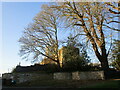
10
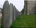
Pickwell gravestones
In the churchyard of All Saints.
Image: © Mat Fascione
Taken: 21 Apr 2008
0.10 miles