IMAGES TAKEN NEAR TO
Rotherby Lane, MELTON MOWBRAY, LE14 2NW
Introduction
This page details the photographs taken nearby to Rotherby Lane, LE14 2NW by members of the Geograph project.
The Geograph project started in 2005 with the aim of publishing, organising and preserving representative images for every square kilometre of Great Britain, Ireland and the Isle of Man.

There are currently over 7.5m images from over14,400 individuals and you can help contribute to the project by visiting https://www.geograph.org.uk
Image Map
Images are licensed for reuse under creativecommons.org/licenses/by-sa/2.0
Notes
- Clicking on the map will re-center to the selected point.
- The higher the marker number, the further away the image location is from the centre of the postcode.
Image Listing (126 Images Found)
Images are licensed for reuse under creativecommons.org/licenses/by-sa/2.0
Image
Details
Distance
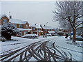
1
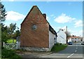
Zion House, Rotherby Lane, Frisby on the Wreake
Mid 17th century thatched farmhouse, partially timber framed. Remodelled in 1725 but with later alterations and additions. The date can just be made out in dark vitrified brickwork in the upper part of the gable. The house appears to be currently unoccupied. Listed Grade II.
Image: © Alan Murray-Rust
Taken: 28 Apr 2015
0.02 miles
2
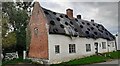
Thatched house with roof held with tyres on west side of Rotherby Lane
Image: © Roger Templeman
Taken: 28 Sep 2022
0.02 miles
3
Zion House, Rotherby Lane, Frisby on the Wreake
Mid 17th century thatched farmhouse, partially timber framed. Remodelled in 1725 but with later alterations and additions. The house appears to be currently unoccupied. Listed Grade II.
Image: © Alan Murray-Rust
Taken: 28 Apr 2015
0.03 miles
4
"Recycling" in Frisby on the Wreake, Melton Mowbray
One way of stopping rain coming through leaky thatch! I've seen this done on hay stacks and silage clamps but never on a house.
Image: © Kate Jewell
Taken: 18 Aug 2005
0.03 miles
5
Hall Orchard Lane from near the school
Image: © Andrew Tatlow
Taken: 6 Jan 2010
0.03 miles
6
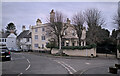
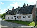
The Limes
An early 19th century house, and grade II listed - see https://historicengland.org.uk/listing/the-list/list-entry/1061264?section=official-list-entry .
Image: © Bob Harvey
Taken: 2 Feb 2023
0.05 miles
7
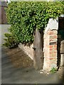
Village pump, Rotherby Lane, Frisby on the Wreake
Probably of 19th century origin, enclosed in a wooden box in style typical of the area.
Image: © Alan Murray-Rust
Taken: 28 Apr 2015
0.05 miles
8
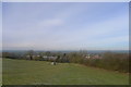
On the Leicestershire Round approaching Frisby on the Wreake
The Wreake Valley beyond
Image: © Tim Heaton
Taken: 31 Jan 2019
0.05 miles
9
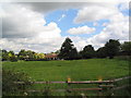
Leicestershire Round to Frisby on the Wreake
The Leicestershire Round from Rotherby approaching Frisby from the west.
Image: © Tim Heaton
Taken: 12 Aug 2007
0.05 miles
10

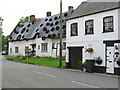
The Limes, Rotherby Lane, Frisby on the Wreake
Early 19th century house, re-fronted in 1834, in stucco with slate roof. Listed Grade II. The view also shows the medieval cross http://www.geograph.org.uk/photo/4462739 ; the patch of granite setts in the middle of the road junction indicates its original location.
Image: © Alan Murray-Rust
Taken: 28 Apr 2015
0.05 miles