IMAGES TAKEN NEAR TO
Carrfields Lane, MELTON MOWBRAY, LE14 2NT
Introduction
This page details the photographs taken nearby to Carrfields Lane, LE14 2NT by members of the Geograph project.
The Geograph project started in 2005 with the aim of publishing, organising and preserving representative images for every square kilometre of Great Britain, Ireland and the Isle of Man.

There are currently over 7.5m images from over14,400 individuals and you can help contribute to the project by visiting https://www.geograph.org.uk
Image Map
Images are licensed for reuse under creativecommons.org/licenses/by-sa/2.0
Notes
- Clicking on the map will re-center to the selected point.
- The higher the marker number, the further away the image location is from the centre of the postcode.
Image Listing (188 Images Found)
Images are licensed for reuse under creativecommons.org/licenses/by-sa/2.0
Image
Details
Distance
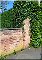
1
Eastern boundary wall of cemetery on Mill Lane
There is an Ordnance Survey benchmark Image on the right hand wall pier
Image: © Roger Templeman
Taken: 28 Sep 2022
0.04 miles
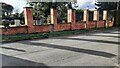
2
Brick wall on west side of Mill Lane
There is an Ordnance Survey benchmark Image on the wall pier
Image: © phil Richards
Taken: 2 Jun 2021
0.04 miles
3
Benchmark on brick wall pier on west side of Mill Lane
Ordnance Survey cut mark benchmark described on the Bench Mark Database at www.bench-marks.org.uk/bm148406
Image: © phil Richards
Taken: 2 Jun 2021
0.04 miles
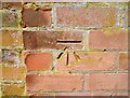
4

Benchmark on pier of wall of cemetery on west side of Mill Lane
Ordnance Survey cut mark benchmark levelled at 69.708m above Newlyn Datum verified 1962
Image: © Roger Templeman
Taken: 28 Sep 2022
0.04 miles
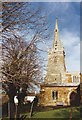
7
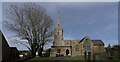
The Church of St Thomas of Canterbury
A grade I listed building, of ironstone and with a limestone ashlar-clad tower. It has its origins in the 12th century, but with not a single century since having failed to make its mark on the fabric.
See https://historicengland.org.uk/listing/the-list/list-entry/1360878?section=official-list-entry for the Historic England listing.
This is a composite picture, formed of around 12 individual shots, because there is little space in the churchyard to stand well back. It was stitched with Microsoft ICE.
Image: © Bob Harvey
Taken: 5 Feb 2023
0.06 miles
8
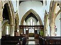
Church of St Thomas of Canterbury, Frisby on the Wreake
The nave looking east. The arcades and chancel arch are mid 14th century in Perpendicular style. The style of some of the hood mould stops suggest that they may be incorporations from the earlier church.
Image: © Alan Murray-Rust
Taken: 28 Apr 2015
0.06 miles
9
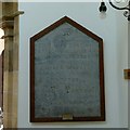
Church of St Thomas of Canterbury, Frisby on the Wreake
Tablet commemorating the re-leading of the roof in 1733.
Image: © Alan Murray-Rust
Taken: 28 Apr 2015
0.06 miles
10
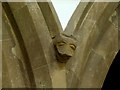
Church of St Thomas of Canterbury, Frisby on the Wreake
Hood mould stop, north aisle arcade. The style is distinctly Romanesque and this may be an early corbel incorporated in the 14th century rebuilding.
Image: © Alan Murray-Rust
Taken: 28 Apr 2015
0.06 miles