IMAGES TAKEN NEAR TO
Gaddesby Lane, MELTON MOWBRAY, LE14 2LL
Introduction
This page details the photographs taken nearby to Gaddesby Lane, LE14 2LL by members of the Geograph project.
The Geograph project started in 2005 with the aim of publishing, organising and preserving representative images for every square kilometre of Great Britain, Ireland and the Isle of Man.

There are currently over 7.5m images from over14,400 individuals and you can help contribute to the project by visiting https://www.geograph.org.uk
Image Map
Images are licensed for reuse under creativecommons.org/licenses/by-sa/2.0
Notes
- Clicking on the map will re-center to the selected point.
- The higher the marker number, the further away the image location is from the centre of the postcode.
Image Listing (11 Images Found)
Images are licensed for reuse under creativecommons.org/licenses/by-sa/2.0
Image
Details
Distance
1
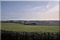
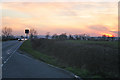
Leicestershire
The A607 has all the appearance of an ancient ridgeway - the road runs along the top of a long ridge between the valleys of the River Wreake and the Rearsby Brook. Here I am standing on the verge looking south-east into the valley of the Brook, which must have been a substantial flow in post-glacial times
Image: © Bob Harvey
Taken: 5 Feb 2023
0.08 miles
2
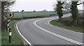
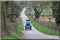
The A607 Leicester Road
Heading towards Melton Mowbray.
Image: © Mat Fascione
Taken: 15 Mar 2009
0.13 miles
3
Junction of Rotherby Lane with the A607 Leicester Road
Image: © Andrew Tatlow
Taken: 3 Feb 2009
0.16 miles
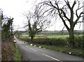
4
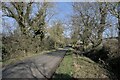
Rotherby Lane
Lane down from the ridge into Frisby on the Wreake.
Image: © Bob Harvey
Taken: 5 Feb 2023
0.18 miles
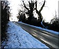
5
Leicester Road near Frisby on the Wreake, Leicestershire
Commuter traffic on the way from Leicester to Melton on the A607 at the top of the hill above the Wreake Valley. Looking west from the centre of the square.
Image: © Kate Jewell
Taken: 22 Mar 2006
0.21 miles
6
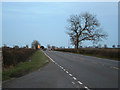
Leicester Road near Frisby on the Wreake, Leicestershire
Looking towards Melton Mowbray along the A607. This stretch of the road is 100 metres above sea level and runs along this ridge for three kilometres before dropping down towards Kirby Bellars.
Image: © Kate Jewell
Taken: 22 Mar 2006
0.21 miles
7
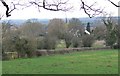
View towards Rotherby
Looking west from Rotherby Lane.
Image: © Mat Fascione
Taken: 15 Mar 2009
0.22 miles
8
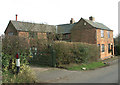
Converted cottages near Rotherby
This house was converted by my friend David Hall, who now lives in Vancouver, Canada, from two cottages. He lived here for many years, and the farm beyond belongs to his father.
Image: © Peter Langsdale
Taken: 9 Feb 2004
0.23 miles
9
Gaddesby Lane heading towards Gaddesby
Image: © Mat Fascione
Taken: 15 Mar 2009
0.23 miles
10
Gaddesby Lane from near to A607 junction
Image: © Andrew Tatlow
Taken: 14 Feb 2012
0.23 miles