IMAGES TAKEN NEAR TO
Post Office Lane, MELTON MOWBRAY, LE14 2HX
Introduction
This page details the photographs taken nearby to Post Office Lane, LE14 2HX by members of the Geograph project.
The Geograph project started in 2005 with the aim of publishing, organising and preserving representative images for every square kilometre of Great Britain, Ireland and the Isle of Man.

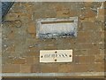
There are currently over 7.5m images from over14,400 individuals and you can help contribute to the project by visiting https://www.geograph.org.uk
Image Map
Images are licensed for reuse under creativecommons.org/licenses/by-sa/2.0
Notes
- Clicking on the map will re-center to the selected point.
- The higher the marker number, the further away the image location is from the centre of the postcode.
Image Listing (54 Images Found)
Images are licensed for reuse under creativecommons.org/licenses/by-sa/2.0
Image
Details
Distance
1
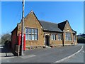
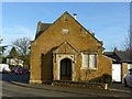
The Old School, Twyford
Built in 1845 as a National School. Now converted to residential use. See http://www.britishlistedbuildings.co.uk/en-189898-the-old-school-twyford-and-thorpe-leices#.VT_kKSFViko for entry in British Listed Buildings.
Image: © Bikeboy
Taken: 14 Apr 2015
0.03 miles
2
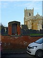
Twyford war memorial
An unusual style, formed of a niche built on top of the churchyard wall.
Image: © Alan Murray-Rust
Taken: 3 Feb 2017
0.03 miles
3
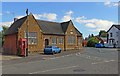
Junction of Main Street and Church Lane, Twyford
Image: © Mat Fascione
Taken: 4 Aug 2007
0.04 miles
4
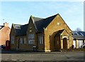
Former village school, Twyford
A pretty little building in ironstone, dated 1845 http://www.geograph.org.uk/photo/5273408 , and Listed Grade II. Converted to a house, presumably in 1980 which is the date on the plate below the original datestone.
The K6 telephone kiosk is also Listed Grade II.
Image: © Alan Murray-Rust
Taken: 3 Feb 2017
0.04 miles
5
Former village school, Twyford
1845 datestone, and 1980 plaque, the latter also done in Roman numerals. See http://www.geograph.org.uk/photo/5273401 .
Image: © Alan Murray-Rust
Taken: 3 Feb 2017
0.04 miles
6
Former village school, Twyford
The south gable of the building, with porch.
Image: © Alan Murray-Rust
Taken: 3 Feb 2017
0.04 miles
7
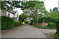
Hollands Lane leading off Church Lane, Twyford
The footpath leads to Burrough on the Hill
Image: © Tim Heaton
Taken: 5 Jun 2019
0.05 miles
9
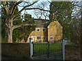
The Manor, Twyford
A late 17th century farmhouse with 19th century extensions. The door and windows visible in this shot seem to belong to the original period. Listed Grade II.
Image: © Alan Murray-Rust
Taken: 3 Feb 2017
0.06 miles
10
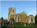
Church of St Andrew, Twyford
View from the south east showing the chancel which was rebuilt in 1775, unusually with no window in the south wall. The former line of the chancel roof is very clear on the end wall of the nave.
Image: © Alan Murray-Rust
Taken: 3 Feb 2017
0.06 miles