IMAGES TAKEN NEAR TO
Main Road, MELTON MOWBRAY, LE14 2HL
Introduction
This page details the photographs taken nearby to Main Road, LE14 2HL by members of the Geograph project.
The Geograph project started in 2005 with the aim of publishing, organising and preserving representative images for every square kilometre of Great Britain, Ireland and the Isle of Man.

There are currently over 7.5m images from over14,400 individuals and you can help contribute to the project by visiting https://www.geograph.org.uk
Image Map
Images are licensed for reuse under creativecommons.org/licenses/by-sa/2.0
Notes
- Clicking on the map will re-center to the selected point.
- The higher the marker number, the further away the image location is from the centre of the postcode.
Image Listing (51 Images Found)
Images are licensed for reuse under creativecommons.org/licenses/by-sa/2.0
Image
Details
Distance
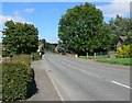
1
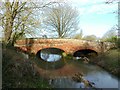
Lewin's Bridge, Twyford
Built around 1780 by Mr Lewin. A substantial structure for the period on a road which does not appear to have been a turnpike, even though it is the main road between Melton Mowbray and Market Harborough. Listed Grade II.
Image: © Alan Murray-Rust
Taken: 3 Feb 2017
0.03 miles
2
Muddy Waters Running Deep!
The brook in Twyford swollen by heavy overnight rain.
Image: © Kate Jewell
Taken: 30 Mar 2006
0.03 miles
3
Lewin's Bridge, Twyford
Built around 1780 by Mr Lewin. A substantial structure for the period on a road which does not appear to have been a turnpike, even though it is the main road between Melton Mowbray and Market Harborough. Listed Grade II.
There is a bench mark http://www.geograph.org.uk/photo/5273438 on the right hand parapet over the central arch.
Image: © Alan Murray-Rust
Taken: 3 Feb 2017
0.03 miles
4
Brook in Twyford, Leicestershire
Interesting comparison with Kate Jewell's photo from nearly 18 months earlier: Image Amazing what a difference the weather makes!
Image: © Mat Fascione
Taken: 4 Aug 2007
0.04 miles
6
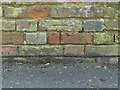
Bench mark, Lewin's Bridge, Twyford
See http://www.geograph.org.uk/photo/5273442 for location.
Image: © Alan Murray-Rust
Taken: 3 Feb 2017
0.06 miles
7
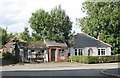
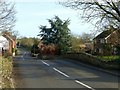
Twyford: a contrast
A smart bungalow and some dilapidated buildings at the entrance to Home Farm - formerly shops or workshops, I imagine.
Image: © John Sutton
Taken: 4 Oct 2012
0.06 miles
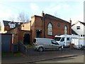
8
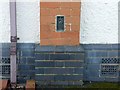
Flush bracket bench mark 10167, Twyford Village Hall
See http://www.geograph.org.uk/photo/5273447 for location.
Image: © Alan Murray-Rust
Taken: 3 Feb 2017
0.07 miles
9
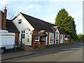
Twyford Village Hall
There is a bench mark http://www.geograph.org.uk/photo/5273444 on the second brick buttress.
Image: © Alan Murray-Rust
Taken: 3 Feb 2017
0.08 miles
10
Former Wesleyan Methodist Chapel, Twyford
Now a private house. Dated 1845 http://www.geograph.org.uk/photo/5273454 .
Image: © Alan Murray-Rust
Taken: 3 Feb 2017
0.08 miles