IMAGES TAKEN NEAR TO
Top End, MELTON MOWBRAY, LE14 2HA
Introduction
This page details the photographs taken nearby to Top End, LE14 2HA by members of the Geograph project.
The Geograph project started in 2005 with the aim of publishing, organising and preserving representative images for every square kilometre of Great Britain, Ireland and the Isle of Man.

There are currently over 7.5m images from over14,400 individuals and you can help contribute to the project by visiting https://www.geograph.org.uk
Image Map
Images are licensed for reuse under creativecommons.org/licenses/by-sa/2.0
Notes
- Clicking on the map will re-center to the selected point.
- The higher the marker number, the further away the image location is from the centre of the postcode.
Image Listing (52 Images Found)
Images are licensed for reuse under creativecommons.org/licenses/by-sa/2.0
Image
Details
Distance
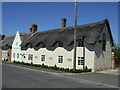
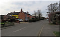
2
Dalefarm Cottage and Stook Cottage on NE side of Top End
Image: © Luke Shaw
Taken: 27 Sep 2022
0.01 miles
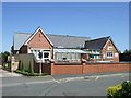

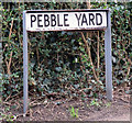
8
Pebble Yard
A very small road in the middle of Great Dalby.
Image: © Andrew Tatlow
Taken: 27 Feb 2016
0.08 miles
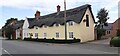
9
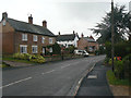
Top End, Great Dalby
This part of the village is shown on OS maps as Upper End, although the road name appears as Top End.
Image: © Alan Murray-Rust
Taken: 4 Aug 2011
0.08 miles
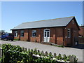
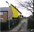
10
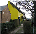
Rose Cottage and Pebble Yard
The colour of Rose Cottage was recently changed from white to yellow!
Image: © Andrew Tatlow
Taken: 27 Feb 2016
0.08 miles