IMAGES TAKEN NEAR TO
Burrough Road, MELTON MOWBRAY, LE14 2EP
Introduction
This page details the photographs taken nearby to Burrough Road, LE14 2EP by members of the Geograph project.
The Geograph project started in 2005 with the aim of publishing, organising and preserving representative images for every square kilometre of Great Britain, Ireland and the Isle of Man.

There are currently over 7.5m images from over14,400 individuals and you can help contribute to the project by visiting https://www.geograph.org.uk
Image Map
Images are licensed for reuse under creativecommons.org/licenses/by-sa/2.0
Notes
- Clicking on the map will re-center to the selected point.
- The higher the marker number, the further away the image location is from the centre of the postcode.
Image Listing (8 Images Found)
Images are licensed for reuse under creativecommons.org/licenses/by-sa/2.0
Image
Details
Distance
1
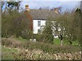
Moscow Farm House
The building is shown on old Ordnance Survey maps as Great Dalby Lodge
Image: © Andrew Tatlow
Taken: 3 Apr 2006
0.03 miles
3
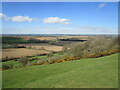
View from Burrough Hill
Moscow Farm near the centre of the picture.
Image: © Jonathan Thacker
Taken: 29 Mar 2021
0.05 miles
4
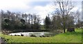
Moscow Farm Pond
But where are the ducks?
Image: © Andrew Tatlow
Taken: 3 Apr 2006
0.09 miles
5
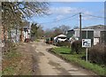
Moscow Farm Buildings
The farm is almost part of the road! Straight on is Moscow Lane which joins Sandy Lane slightly to the south of the Great Dalby to Little Dalby road. Until about 2002 Moscow Lane was very overgrown and in wet weather very muddy and all but impassable. It is much better now!
Image: © Andrew Tatlow
Taken: 3 Apr 2006
0.11 miles
6
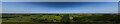
From the ramparts
The view from the walls of Burrough Hill Fort, over the Leicestershire plain
Image: © Bob Harvey
Taken: 16 Jul 2021
0.12 miles
7
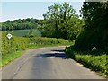
Passing place on Melton Lane
At this point descending Salter's Hill near Moscow Farm.
Image: © Mat Fascione
Taken: 1 Jun 2009
0.20 miles
8
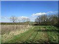
Track near Moscow Lodge
A Public Access Route.
Image: © Jonathan Thacker
Taken: 29 Mar 2021
0.21 miles