IMAGES TAKEN NEAR TO
Salters Hill Drive, MELTON MOWBRAY, LE14 2DD
Introduction
This page details the photographs taken nearby to Salters Hill Drive, LE14 2DD by members of the Geograph project.
The Geograph project started in 2005 with the aim of publishing, organising and preserving representative images for every square kilometre of Great Britain, Ireland and the Isle of Man.

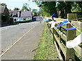
There are currently over 7.5m images from over14,400 individuals and you can help contribute to the project by visiting https://www.geograph.org.uk
Image Map
Images are licensed for reuse under creativecommons.org/licenses/by-sa/2.0
Notes
- Clicking on the map will re-center to the selected point.
- The higher the marker number, the further away the image location is from the centre of the postcode.
Image Listing (14 Images Found)
Images are licensed for reuse under creativecommons.org/licenses/by-sa/2.0
Image
Details
Distance
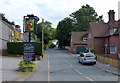
3
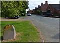
Great Dalby Road towards Thorpe Satchville
Image: © Mat Fascione
Taken: 1 Jun 2009
0.12 miles
4
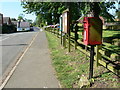
Postbox along the Main Street
In the village of Thorpe Satchville.
Image: © Mat Fascione
Taken: 26 May 2012
0.12 miles
5
Jubilee bunting on Main Street
In the village of Thorpe Satchville.
Image: © Mat Fascione
Taken: 26 May 2012
0.12 miles
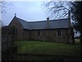
7
St Michael and All Angels Thorpe Satchville
Image: © Andrew Tatlow
Taken: 9 Sep 2006
0.15 miles
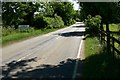
8
South along the Main Street in Thorpe Satchville
Image: © Mat Fascione
Taken: 5 Jul 2014
0.15 miles
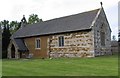
9
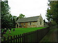
Church of St Michael and All Angels, Thorpe Satchville
The Leicestershire Round crosses the churchyard
Image: © Tim Heaton
Taken: 7 Oct 2007
0.16 miles
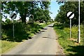
10
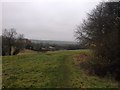
Leicestershire Round towards Ashby Folville
Image: © Dave Thompson
Taken: 8 Dec 2016
0.17 miles