IMAGES TAKEN NEAR TO
The Brickyard, MELTON MOWBRAY, LE14 2BL
Introduction
This page details the photographs taken nearby to The Brickyard, LE14 2BL by members of the Geograph project.
The Geograph project started in 2005 with the aim of publishing, organising and preserving representative images for every square kilometre of Great Britain, Ireland and the Isle of Man.

There are currently over 7.5m images from over14,400 individuals and you can help contribute to the project by visiting https://www.geograph.org.uk
Image Map
Images are licensed for reuse under creativecommons.org/licenses/by-sa/2.0
Notes
- Clicking on the map will re-center to the selected point.
- The higher the marker number, the further away the image location is from the centre of the postcode.
Image Listing (90 Images Found)
Images are licensed for reuse under creativecommons.org/licenses/by-sa/2.0
Image
Details
Distance
1
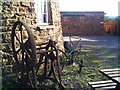
Ancient rural implements
There are two old implements at the base of Wymondham Mill. One is a horse drawn single furrow plough and the other looks to be a windlass (perhaps to do with turning the mill in days gone by).
Image: © Brian Green
Taken: 19 Nov 2006
0.04 miles
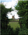
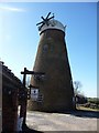
2
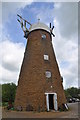
Wymondham Windmill - External View
A look at the ironstone tower (Jurassic sediments) with brick top. A Ogee cap once held 6 sails.
Image: © Ashley Dace
Taken: 14 May 2011
0.04 miles
3
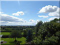
View from Wymondham Windmill
Wymondham Windmill dates from the early 19th century and is undergoing restoration. It is possible to go to the upper floors where views like this are obtained. The cap was replaced at the end of August 2017. At the time of my visit the walls and windows were also being restored. See http://wymondhamwindmill.co.uk/2015/12/14/209/
Image: © Marathon
Taken: 12 Aug 2017
0.05 miles
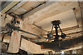
4
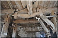
Wymondham Windmill - Meal Floor
The meal floor, the two shoots for flour can be seen in here along with the governors and tentering beams. Although not in the picture a radio enthusiast was set up for mills open weekend.
Image: © Ashley Dace
Taken: 14 May 2011
0.06 miles
5
Wymondham Windmill
Seen from the footpath behind the navvy houses http://www.geograph.org.uk/photo/1923056. See Kate Jewell's photograph for the windmill's history http://www.geograph.org.uk/photo/41128 .
Image: © John Sutton
Taken: 17 Jun 2010
0.06 miles
6
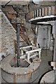
Wymondham Windmill - Stones
A view of the great spur wheel, stone nut and bar to the runner stone.
Image: © Ashley Dace
Taken: 14 May 2011
0.06 miles
7
Wymondham Windmill - Governor
Another view (see below for more) of a governor in the mill.
Image: © Ashley Dace
Taken: 14 May 2011
0.06 miles
8
Wymondham Windmill
Now the landmark for a tearoom.
Image: © Christine Johnstone
Taken: 18 Mar 2011
0.06 miles
9
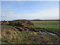
Agricultural waste near Wymondham
Waiting to be recycled!
Wymondham windmill in the distance in the centre of the picture.
Image: © Jonathan Thacker
Taken: 3 Feb 2020
0.06 miles
10
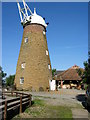
Wymondham Windmill, Leicestershire
Built in 1814 this mill was grinding corn until 1952 and cattle feed until 1960. It is now the main feature of a craft centre There are plans to restore it fully. Built from local ironstone and topped with brick, the Windmill is a five-storey tower mill and is known as a Six Arm Lincolnshire Cross. It is one of only four six-sailed windmills remaining in the country.
Image: © Kate Jewell
Taken: 21 Aug 2005
0.07 miles