IMAGES TAKEN NEAR TO
West Well Gate, MELTON MOWBRAY, LE14 2BE
Introduction
This page details the photographs taken nearby to West Well Gate, LE14 2BE by members of the Geograph project.
The Geograph project started in 2005 with the aim of publishing, organising and preserving representative images for every square kilometre of Great Britain, Ireland and the Isle of Man.

There are currently over 7.5m images from over14,400 individuals and you can help contribute to the project by visiting https://www.geograph.org.uk
Image Map
Images are licensed for reuse under creativecommons.org/licenses/by-sa/2.0
Notes
- Clicking on the map will re-center to the selected point.
- The higher the marker number, the further away the image location is from the centre of the postcode.
Image Listing (15 Images Found)
Images are licensed for reuse under creativecommons.org/licenses/by-sa/2.0
Image
Details
Distance
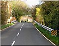
1
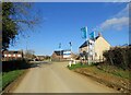
Glebe Road/Glebe Rise junction
Glebe rise is a new housing development.
Image: © Andrew Tatlow
Taken: 29 Mar 2021
0.03 miles
3
Glebe Rise junction
Glebe Rise is a new housing development.
Image: © Andrew Tatlow
Taken: 29 Mar 2021
0.05 miles
4

Signs at end of Glebe Rise
Glebe Rise is a new housing development.
Image: © Andrew Tatlow
Taken: 29 Mar 2021
0.05 miles
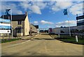
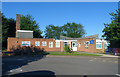
6

Sign at St Peter CE Primary School
The sign was out of date when the picture was taken as the school had converted to Academy Status and was therefore no longer "Aided".
Image: © Andrew Tatlow
Taken: 30 Jun 2015
0.08 miles
8

Welcome notice at St Peter CE Primary School
The sign was out of date when the picture was taken as there had been a change of Head Teacher and the school had converted to Academy Status and was therefore no longer "Aided".
Image: © Andrew Tatlow
Taken: 30 Jun 2015
0.08 miles
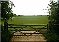
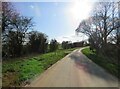
10
Well protected ex-railway bridge
This ex-railway bridge is well protected against vehicles ploughing through the parapets and onto the tracks........except the railway was dismantled many years ago!
A concrete mixer landed on a train in Surrey recently!
Image
Image
Image: © Andrew Tatlow
Taken: 7 Nov 2010
0.14 miles