IMAGES TAKEN NEAR TO
Church Lane, MELTON MOWBRAY, LE14 2AB
Introduction
This page details the photographs taken nearby to Church Lane, LE14 2AB by members of the Geograph project.
The Geograph project started in 2005 with the aim of publishing, organising and preserving representative images for every square kilometre of Great Britain, Ireland and the Isle of Man.

There are currently over 7.5m images from over14,400 individuals and you can help contribute to the project by visiting https://www.geograph.org.uk
Image Map
Images are licensed for reuse under creativecommons.org/licenses/by-sa/2.0
Notes
- Clicking on the map will re-center to the selected point.
- The higher the marker number, the further away the image location is from the centre of the postcode.
Image Listing (113 Images Found)
Images are licensed for reuse under creativecommons.org/licenses/by-sa/2.0
Image
Details
Distance
1
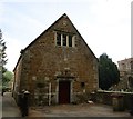
The former Grammar School, Wymondham
Dates from 1637 though altered in 1885 when it became a reading room https://historicengland.org.uk/listing/the-list/list-entry/1061253
Image: © Jonathan Thacker
Taken: 11 May 2018
0.03 miles
2
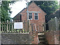
Telephone Exchange, Wymondham, Leics
Situated in Main Street opposite the road to Garthorpe, the front building would appear to be the original TE with the rear building added later. Besides Wymondham, this TE also serves Edmondthorpe, Garthorpe, Saxby and Teigh nearby. It has (01572) 787xxx numbers and its postcode is LE14 2AG.
Image: © David Hillas
Taken: 3 Jul 2009
0.03 miles
3

Church Lane, Wymondham
Looking south-eastward.
Image: © Peter Wood
Taken: 11 Oct 2021
0.03 miles
4
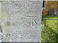
Ordnance Survey Cut Mark
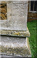
This mark can be found on the wall of St Peter's Church, Wymondham.
The recorded details give a height of 103.571 metres above sea level.
For more details see : https://www.bench-marks.org.uk/bm49333
Image: © Peter Wood
Taken: 11 Oct 2021
0.04 miles
5
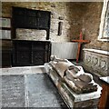
Wymondham, St. Peter's Church: Large effigy of a cross-legged c13th knight 1
Image: © Michael Garlick
Taken: 28 Jul 2023
0.04 miles
6
Benchmark on the tower of St Peter's Church
Ordnance Survey cut mark benchmark described on the Bench Mark Database at www.bench-marks.org.uk/bm49333
Image: © Roger Templeman
Taken: 10 Sep 2017
0.05 miles
7
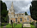
St Peter's Church, Wymondham
In its wide main street were held for centuries the weekly market and the annual fair granted in 1303. According to 'A Shell Guide to Leicestershire' by W. G. Hoskins: "It was once a much larger place and the back lanes are probably decayed streets with old walls, old orchards, ironstone cottages, and farmhouses complete with white doves. There was probably a Roman villa here adjoining the present Wymondham House, as rather more than a century ago a considerable area of Roman pavement was discovered and other Roman remains have been found.."
St Peter's Church is mostly of ironstone. Although the church has transepts, the tower is at the west end and not over the crossing. The tower dates from the late 13th century, as does the chancel which is the other oldest part. There are Perpendicular additions to the tower and the spire which are of limestone. Pevsner calls the five-light east window "splendid".
Image: © Marathon
Taken: 12 Aug 2017
0.05 miles
8
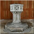
Wymondham, St. Peter's Church: The font
Image: © Michael Garlick
Taken: 28 Jul 2023
0.05 miles
9
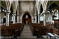
Wymondham, St. Peter's Church: The nave from the chancel
Image: © Michael Garlick
Taken: 28 Jul 2023
0.05 miles
10
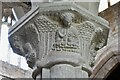
Wymondham, St. Peter's Church: Nave capital 1
Image: © Michael Garlick
Taken: 28 Jul 2023
0.05 miles