IMAGES TAKEN NEAR TO
Chapel Lane, MELTON MOWBRAY, LE14 2AA
Introduction
This page details the photographs taken nearby to Chapel Lane, LE14 2AA by members of the Geograph project.
The Geograph project started in 2005 with the aim of publishing, organising and preserving representative images for every square kilometre of Great Britain, Ireland and the Isle of Man.

There are currently over 7.5m images from over14,400 individuals and you can help contribute to the project by visiting https://www.geograph.org.uk
Image Map
Images are licensed for reuse under creativecommons.org/licenses/by-sa/2.0
Notes
- Clicking on the map will re-center to the selected point.
- The higher the marker number, the further away the image location is from the centre of the postcode.
Image Listing (107 Images Found)
Images are licensed for reuse under creativecommons.org/licenses/by-sa/2.0
Image
Details
Distance
1
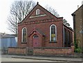
Wesleyan Chapel 1891
On the Main Street of Wymondham.
Image: © Mat Fascione
Taken: 21 Apr 2008
0.05 miles
2
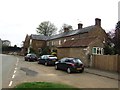
Smithy and former Three Horseshoes Inn
At the start of the 19th century the blacksmith opened a pub next to the forge. Fittingly it was known as the Three Horseshoes.
Image: © John M
Taken: 5 May 2013
0.06 miles
3
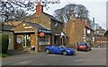
Wymondham Cottage Stores and Post Office
With the Berkeley Arms public house behind.
Image: © Mat Fascione
Taken: 21 Apr 2008
0.06 miles
4

Church Lane, Wymondham
Looking south-eastward.
Image: © Peter Wood
Taken: 11 Oct 2021
0.06 miles
5
Former Three Horseshoes Inn
The pub dated from the early 19th century when it was opened by the local blacksmith. Only the painted sign remains.
Image: © John M
Taken: 5 May 2013
0.06 miles
6
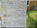
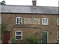
Ordnance Survey Cut Mark
This mark can be found on the wall of St Peter's Church, Wymondham.
The recorded details give a height of 103.571 metres above sea level.
For more details see : https://www.bench-marks.org.uk/bm49333
Image: © Peter Wood
Taken: 11 Oct 2021
0.06 miles
9
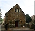
The former Grammar School, Wymondham
Dates from 1637 though altered in 1885 when it became a reading room https://historicengland.org.uk/listing/the-list/list-entry/1061253
Image: © Jonathan Thacker
Taken: 11 May 2018
0.07 miles
10
The Berkeley Arms, Wymondham, Leicestershire
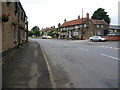
The Berkeley Arms in Wymondham was the only eatery in Leicestershire to make it into the Good Food Guide 2002. It stands at the junction of Butts Lane and the wide Main Street
Image: © Kate Jewell
Taken: 12 Aug 2005
0.07 miles