IMAGES TAKEN NEAR TO
Thorpe Road, MELTON MOWBRAY, LE13 1SQ
Introduction
This page details the photographs taken nearby to Thorpe Road, LE13 1SQ by members of the Geograph project.
The Geograph project started in 2005 with the aim of publishing, organising and preserving representative images for every square kilometre of Great Britain, Ireland and the Isle of Man.

There are currently over 7.5m images from over14,400 individuals and you can help contribute to the project by visiting https://www.geograph.org.uk
Image Map (Loading...)


Getting Data...Please wait
Leaflet Map data © OpenStreetMap
Images are licensed for reuse under creativecommons.org/licenses/by-sa/2.0
Notes
- Clicking on the map will re-center to the selected point.
- The higher the marker number, the further away the image location is from the centre of the postcode.
Image Listing (104 Images Found)
Images are licensed for reuse under creativecommons.org/licenses/by-sa/2.0
Image
Details
Distance
1
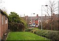
Stafford Avenue southwards
Early afternoon on Christmas Day 2023.
Image: © Andrew Tatlow
Taken: 25 Dec 2023
0.03 miles
2
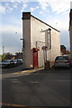
#97A Thorpe Road
There is an OS benchmark Image on the narrow wall of the house, right of the lamppost
Image: © Roger Templeman
Taken: 30 Apr 2016
0.04 miles
3
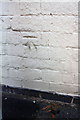
Benchmark on #97A Thorpe Road
Ordnance Survey cut mark benchmark described on the Bench Mark Database at http://www.bench-marks.org.uk/bm70610
Image: © Roger Templeman
Taken: 30 Apr 2016
0.04 miles
4
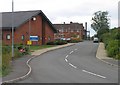
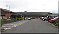
Melton Mowbray Hospital Entrance 2
St Mary's Hospital in the background. The new hospital to the left.
Image: © Andrew Tatlow
Taken: 3 Aug 2010
0.06 miles

6

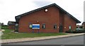
St Mary's Hospital, Melton Mowbray, Leics.
As this particular block is not boarded up perhaps it is still offering some services for families, children and young people, despite some closures of other units here. This building can be approached via a 150m long footpath from nearby Thorpe Road.
Image: © David Hallam-Jones
Taken: 3 Dec 2017
0.07 miles
7
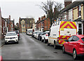
St Mary's Hospital, Melton Mowbray, Leics.
This footpath provides a link between the functioning part of the hospital and Thorpe Road (ahead). This boarded-up prefabricated building, plus the area encompassed by plant covered security fencing, highlights the fact that the older, former workhouse part of the hospital is no longer functioning.
Image: © David Hallam-Jones
Taken: 3 Dec 2017
0.07 miles
8
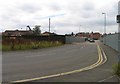
Approach to new Melton Hospital
Scrapyard to the left and factories to the right.
Image: © Andrew Tatlow
Taken: 3 Aug 2010
0.07 miles