IMAGES TAKEN NEAR TO
Thorpe Road, MELTON MOWBRAY, LE13 1SG
Introduction
This page details the photographs taken nearby to Thorpe Road, LE13 1SG by members of the Geograph project.
The Geograph project started in 2005 with the aim of publishing, organising and preserving representative images for every square kilometre of Great Britain, Ireland and the Isle of Man.

There are currently over 7.5m images from over14,400 individuals and you can help contribute to the project by visiting https://www.geograph.org.uk
Image Map (Loading...)


Getting Data...Please wait
Leaflet Map data © OpenStreetMap
Images are licensed for reuse under creativecommons.org/licenses/by-sa/2.0
Notes
- Clicking on the map will re-center to the selected point.
- The higher the marker number, the further away the image location is from the centre of the postcode.
Image Listing (163 Images Found)
Images are licensed for reuse under creativecommons.org/licenses/by-sa/2.0
Image
Details
Distance
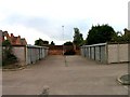
1
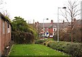
Way through to Thorpe Road
In former times there would have been no bollards.
Image: © Andrew Tatlow
Taken: 9 Sep 2010
0.02 miles
2
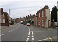
Junction of Thorpe Road and Stafford Avenue
Looking towards the centre of Melton Mowbray along Thorpe Road with Stafford Avenue to the right. The knife-edged building to the right was once a shop with the former frontage marked by the different brickwork.
Image: © Andrew Tatlow
Taken: 13 May 2009
0.02 miles
3
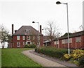
St Mary's Hospital, Melton Mowbray, Leics.
Some buildings remaining in use, e.g. the large house ahead - marked "Children's Community House" - whilst others are very obviously boarded up. This footpath links Thorpe Road, 75m behind the photographer, with the functioning part of the hospital behind and to the right of the Children's Community House.
Image: © David Hallam-Jones
Taken: 3 Dec 2017
0.02 miles
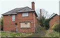
4
Off Thorpe Road, Melton Mowbray, Leics.
Originally built as a workhouse in 1836, these premises were designed by Charles Dyer and followed an elongated H-plan plan, rather than one of radial layouts that were more popular at the time. An infirmary designed by R.W. Johnson was constructed on the east side of the workhouse in 1869-70. At its centre were a surgery, a kitchen and nurses’ quarters. Male and female patients used separate entrances, one on each side of the infirmary. A vagrants' block was located on the south side that also contained “work cells’ where stone-breaking was carried out by the inmates. Much later the workhouse became St Mary's Hospital and this was absorbed into the NHS in 1948. These buildings were closed in 2009 or 2010.
Image: © David Hallam-Jones
Taken: 3 Dec 2017
0.02 miles
5
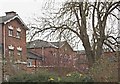
St Mary's Hospital, Melton Mowbray, Leics.
This footpath provides a link between the functioning part of the hospital and Thorpe Road (ahead). This boarded-up prefabricated building, plus the area encompassed by plant covered security fencing, highlights the fact that the older, former workhouse part of the hospital is no longer functioning.
Image: © David Hallam-Jones
Taken: 3 Dec 2017
0.03 miles
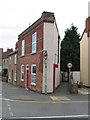
6
St Mary's Hospital, Melton Mowbray, Leics.
Between the workhouse being built in 1836 and it closing - as St Mary's Hospital - in 2009 or 2010, additional buildings and wings were added. This one has the appearance of a small Nurses' Home or a Medical Staff Residence.
Image: © David Hallam-Jones
Taken: 3 Dec 2017
0.03 miles
8
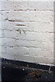
Benchmark on #97A Thorpe Road
Ordnance Survey cut mark benchmark described on the Bench Mark Database at http://www.bench-marks.org.uk/bm70610
Image: © Roger Templeman
Taken: 30 Apr 2016
0.04 miles
10
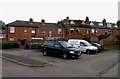
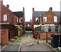
Car park at rear of houses
The houses are on Thorpe Road.Ironing4u is an excellent local company that does the ironing!
Image: © Andrew Tatlow
Taken: 9 Sep 2010
0.04 miles