IMAGES TAKEN NEAR TO
Willcox Drive, MELTON MOWBRAY, LE13 1HH
Introduction
This page details the photographs taken nearby to Willcox Drive, LE13 1HH by members of the Geograph project.
The Geograph project started in 2005 with the aim of publishing, organising and preserving representative images for every square kilometre of Great Britain, Ireland and the Isle of Man.

There are currently over 7.5m images from over14,400 individuals and you can help contribute to the project by visiting https://www.geograph.org.uk
Image Map
Images are licensed for reuse under creativecommons.org/licenses/by-sa/2.0
Notes
- Clicking on the map will re-center to the selected point.
- The higher the marker number, the further away the image location is from the centre of the postcode.
Image Listing (20 Images Found)
Images are licensed for reuse under creativecommons.org/licenses/by-sa/2.0
Image
Details
Distance
1
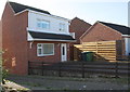
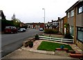
#100A Grange Drive
A new house built on the site of the former double garage of #1 Wilcox Drive. Planning permitted in 2008.
Image: © Roger Templeman
Taken: 4 Oct 2016
0.06 miles
3

The Jubilee Way on the edge of Melton Mowbray
Image: © Jonathan Thacker
Taken: 2 Dec 2021
0.12 miles
4
Jubilee Way and house
Taken from Baldocks Lane.
Image: © Andrew Tatlow
Taken: 2 Nov 2010
0.12 miles

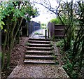
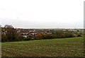
6
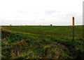
Field and footpath
The map shows the footpath going across the field but there was little sign of it on this day.
Image: © Andrew Tatlow
Taken: 2 Nov 2010
0.13 miles

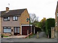
8
Baldocks Lane
Hollygate Close is the street to the left.
Image: © Andrew Tatlow
Taken: 2 Nov 2010
0.14 miles
10
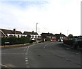
Baldocks Lane/Lowesby Close junction
Image: © Andrew Tatlow
Taken: 28 Oct 2010
0.20 miles