IMAGES TAKEN NEAR TO
Dorian Rise, MELTON MOWBRAY, LE13 0TJ
Introduction
This page details the photographs taken nearby to Dorian Rise, LE13 0TJ by members of the Geograph project.
The Geograph project started in 2005 with the aim of publishing, organising and preserving representative images for every square kilometre of Great Britain, Ireland and the Isle of Man.

There are currently over 7.5m images from over14,400 individuals and you can help contribute to the project by visiting https://www.geograph.org.uk
Image Map
Images are licensed for reuse under creativecommons.org/licenses/by-sa/2.0
Notes
- Clicking on the map will re-center to the selected point.
- The higher the marker number, the further away the image location is from the centre of the postcode.
Image Listing (175 Images Found)
Images are licensed for reuse under creativecommons.org/licenses/by-sa/2.0
Image
Details
Distance
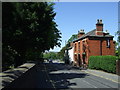
1
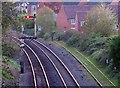
Towards Leicester from Dalby Road railway bridge
Image: © Andrew Tatlow
Taken: 18 Apr 2020
0.04 miles
2
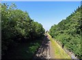
Towards Leicester from Dalby Road B6047 railway bridge
Image: © Andrew Tatlow
Taken: 28 Jun 2018
0.05 miles
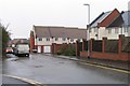
4
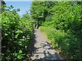
Footpath to Dorian Rise from Dalby road
Image: © Andrew Tatlow
Taken: 28 Jun 2018
0.10 miles
5
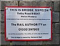
Sign for Bridge GSM2/24 Dalby Road B6047
Image: © Andrew Tatlow
Taken: 28 Jun 2018
0.11 miles
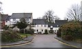

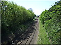
9
Junction of The Uplands and Navication Close
Image: © Andrew Tatlow
Taken: 5 Jan 2011
0.12 miles
10
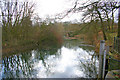
River Eye, Melton Mowbray
This part of the river, which runs past the Play Close and Tennis Centre, is prone to flooding. It was so serious at Easter 1998 that the water reached the top of the marker post and flooded the nearby swimming pool.
Image: © Kate Jewell
Taken: 26 Mar 2006
0.12 miles