IMAGES TAKEN NEAR TO
Kennelmore Road, MELTON MOWBRAY, LE13 0RT
Introduction
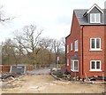
This page details the photographs taken nearby to Kennelmore Road, LE13 0RT by members of the Geograph project.
The Geograph project started in 2005 with the aim of publishing, organising and preserving representative images for every square kilometre of Great Britain, Ireland and the Isle of Man.

There are currently over 7.5m images from over14,400 individuals and you can help contribute to the project by visiting https://www.geograph.org.uk
Image Map (Loading...)


Getting Data...Please wait
Leaflet Map data © OpenStreetMap
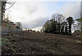
Images are licensed for reuse under creativecommons.org/licenses/by-sa/2.0
Notes
- Clicking on the map will re-center to the selected point.
- The higher the marker number, the further away the image location is from the centre of the postcode.
Image Listing (499 Images Found)
Images are licensed for reuse under creativecommons.org/licenses/by-sa/2.0
Image
Details
Distance
1

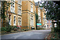
War Memorial Hospital, Melton Mowbray
Crocus along the approach road to the main entrance of the hospital.
Image: © Kate Jewell
Taken: 25 Mar 2006
0.02 miles
2
War Memorial Hospital, Melton Mowbray
This hospital was donated to the town of Melton by Col Richard Dalgleish in 1920. It has recently been sold to a development company to fund the building of new facilities at St Mary's, Melton's other hospital.
Image: © Kate Jewell
Taken: 25 Mar 2006
0.02 miles
3
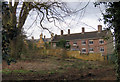
Rear of former Melton Memorial Hospital
The premises of the former Melton Memorial Hospital have recently been cleared and there announcements of it being populated with new build, refurbishments and conversions.A narrow public footpath traverses the area.
Image: © Andrew Tatlow
Taken: 29 Jan 2016
0.03 miles
4

Former Melton Memorial Hospital grounds
The premises of the former Melton Memorial Hospital have recently been cleared and there are announcements of it being populated with new build and conversions.
Image: © Andrew Tatlow
Taken: 29 Jan 2016
0.03 miles
5
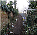
Footpath from Ankle Hill to Dalby Road
The buildings and surrounding land of the former Melton Memorial Hospital have recently been cleared and there are announcements of it being populated with new build, refurbishments and conversions.
A narrow public footpath traverses the edge of the area.
Image: © Andrew Tatlow
Taken: 29 Jan 2016
0.04 miles
6
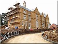
Former War Memorial Hospital, Melton Mowbray, Leics.
This huge converted hunting lodge, that sits at the side of Ankle Hill, was originally known as Hill House. It was built during the reign of the King George III by Mr Hind, a retired leather dealer. Around 1840, Colonel Charles Wyndham took up residency and he renamed the house Wyndham Lodge. Wyndham was pursuing a military career and in 1852, when was appointed as Governor of the Tower of London, he ceased to live here and left Melton Mowbray. Later on, when Wyndham Lodge was leased to Mr William Augustus Chaplin. Chaplin set about demolishing the original building and constructed this building of stone quarried from the nearby village of Wartnaby. He and his family lived here for the next 30 years and additional tenants enjoyed the lodge until the end of World War I when Colonel Richard Dalgleish bought it, along with15 acres of land in 1920. He turned the lodge into The War Memorial Hospital and it was opened by H.R.H. Prince Henry in January 1922. It was then used continuously as a hospital until 2002. Following its closure the building stood empty and unused until its purchase for residential development and the construction of a several dozen houses on the site, all of which overlook the River Eye.
Image: © David Hallam-Jones
Taken: 3 Dec 2017
0.05 miles
7
Ankle Hill Vicinity, Melton Mowbray, Leics.
A new unadopted road linking Ankle Hill - 150 metres ahead - and the Wyndham Grange residential development (i.e. the former War Memorial Hospital).
Image: © David Hallam-Jones
Taken: 3 Dec 2017
0.06 miles
8

War Memorial Hospital Site, Melton Mowbray, Leics.
The former French chateau style stables and carriage block of Wyndham Grange (most recently ancillary buildings of the War Memorial Hospital) being extended and converted into apartments as a part of the overall development of the whole of this 5 acre site into a residential complex. This block can be readily seen from the nearby road, i.e. Ankle Hill.
Image: © David Hallam-Jones
Taken: 3 Dec 2017
0.06 miles
9
End of public footpath from Ankle Hill to Dalby Road
The premises of the former Melton Memorial Hospital have recently been cleared and there are announcements of it being populated with new build, refurbishments and conversions.
A narrow public footpath traverses the area.
Image: © Andrew Tatlow
Taken: 29 Jan 2016
0.07 miles
10
Land to west of former Melton Memorial Hospital
The premises of the former Melton Memorial Hospital have recently been cleared and there announcements of it being populated with new build, refurbishments and conversions.A narrow public footpath traverses the area.
Image: © Andrew Tatlow
Taken: 29 Jan 2016
0.07 miles