IMAGES TAKEN NEAR TO
Shrew Close, MELTON MOWBRAY, LE13 0GQ
Introduction
This page details the photographs taken nearby to Shrew Close, LE13 0GQ by members of the Geograph project.
The Geograph project started in 2005 with the aim of publishing, organising and preserving representative images for every square kilometre of Great Britain, Ireland and the Isle of Man.

There are currently over 7.5m images from over14,400 individuals and you can help contribute to the project by visiting https://www.geograph.org.uk
Image Map (Loading...)


Getting Data...Please wait
Leaflet Map data © OpenStreetMap
Images are licensed for reuse under creativecommons.org/licenses/by-sa/2.0
Notes
- Clicking on the map will re-center to the selected point.
- The higher the marker number, the further away the image location is from the centre of the postcode.
Image Listing (67 Images Found)
Images are licensed for reuse under creativecommons.org/licenses/by-sa/2.0
Image
Details
Distance

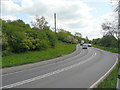
2
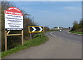
Bend in the A607
Heading towards Melton Mowbray.
Image: © Mat Fascione
Taken: 29 Mar 2014
0.07 miles
3

'Melton Fields' development, Leicester Road, Melton Mowbray
Built close to the River Wreake flood plain. The risk of flooding in Melton Mowbray has been reduced following the construction of a upstream barrage.
Image: © Tim Heaton
Taken: 20 Dec 2017
0.08 miles
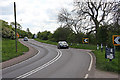
4

Leicester Road (A607) towards Melton Mowbray
Image: © JThomas
Taken: 13 Jul 2012
0.08 miles
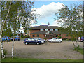
6
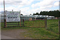
Premier Cane Furniture
It's amazing what you can grow in a greenhouse these days! The company occupies a nursery near New Guadaloupe, off Leicester Road outside Melton Mowbray.
Image: © Martin Addison
Taken: 25 Apr 2009
0.10 miles
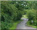
7
Leicester Road
An 'S' bend on the A607 as it passes New Guadaloupe. The trees on the left mark the embankment that used to carry the old Great Northern and London and North Western Joint Railway into Melton Mowbray North station.
Image: © Martin Addison
Taken: 25 Apr 2009
0.13 miles
8
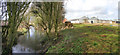
Mill Nursery and Garden Centre
The old mill stream runs alongside the garden centre.
Image: © Kate Jewell
Taken: 26 Mar 2006
0.13 miles
9
A607 Leicester Road near Melton
The embankment to the left is the former Great Northern and London and North Western Railways' joint line connecting Leicester and Market Harborough to Nottingham and Newark.
Image: © Alan Murray-Rust
Taken: 25 Apr 2009
0.13 miles
10
Melton Mowbray Baptist Church
The church moved to this out-of-town location in 1992.
Image: © Alan Murray-Rust
Taken: 25 Apr 2009
0.13 miles