IMAGES TAKEN NEAR TO
Swallowdale Road, MELTON MOWBRAY, LE13 0AU
Introduction
This page details the photographs taken nearby to Swallowdale Road, LE13 0AU by members of the Geograph project.
The Geograph project started in 2005 with the aim of publishing, organising and preserving representative images for every square kilometre of Great Britain, Ireland and the Isle of Man.

There are currently over 7.5m images from over14,400 individuals and you can help contribute to the project by visiting https://www.geograph.org.uk
Image Map
Images are licensed for reuse under creativecommons.org/licenses/by-sa/2.0
Notes
- Clicking on the map will re-center to the selected point.
- The higher the marker number, the further away the image location is from the centre of the postcode.
Image Listing (71 Images Found)
Images are licensed for reuse under creativecommons.org/licenses/by-sa/2.0
Image
Details
Distance
1
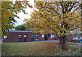
Fallen leaves at Swallowdale Primary School
Image: © Andrew Tatlow
Taken: 13 Oct 2015
0.09 miles
2
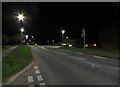
Dalby Road/Swallowdale Road junction at night
Pictures taken during a walk round the block after 11pm one night during the coronavirus crisis. 2 other people and about 4 cars seen in just under an hour. No loud music or anything else to disturb the peace of the night. Even the foxes and badgers were nowhere to be seen!
Image: © Andrew Tatlow
Taken: 11 Apr 2020
0.10 miles
3
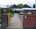
Path to the Swallowdale Primary School main entrance
The school buildings are in the next square!
Image: © Andrew Tatlow
Taken: 13 Oct 2015
0.10 miles
4
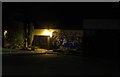
Path to entrance to Swallowdale Primary School at night
Pictures taken during a walk round the block after 11pm one night during the coronavirus crisis. 2 other people and about 4 cars seen in just under an hour. No loud music or anything else to disturb the peace of the night. Even the foxes and badgers were nowhere to be seen! The school building is in the next square.
Image: © Andrew Tatlow
Taken: 11 Apr 2020
0.10 miles
5

Swallowdale Primary School noticeboard
Image: © Andrew Tatlow
Taken: 13 Oct 2015
0.11 miles
6
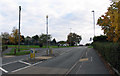
Pedestrian refuge island in Dalby Road
There is a zebra crossing about 100 yards away but it is probably too far for parents and children approaching Swallowdale Primary School from this side.
Image: © Andrew Tatlow
Taken: 13 Oct 2015
0.11 miles
8
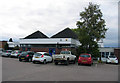
Car parking area at Swallowdale Primary School
The fronts of the cars in the centre are in the next square!
Image: © Andrew Tatlow
Taken: 13 Oct 2015
0.11 miles
9
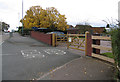
Swallowdale Primary School vehicular entrance
Image: © Andrew Tatlow
Taken: 13 Oct 2015
0.11 miles
10
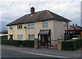
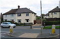
Houses at the Hartopp Road/Dalby Road junction
Image: © Andrew Tatlow
Taken: 13 Oct 2015
0.12 miles