IMAGES TAKEN NEAR TO
Oxford Drive, MELTON MOWBRAY, LE13 0AL
Introduction
This page details the photographs taken nearby to Oxford Drive, LE13 0AL by members of the Geograph project.
The Geograph project started in 2005 with the aim of publishing, organising and preserving representative images for every square kilometre of Great Britain, Ireland and the Isle of Man.

There are currently over 7.5m images from over14,400 individuals and you can help contribute to the project by visiting https://www.geograph.org.uk
Image Map (Loading...)


Getting Data...Please wait
Leaflet Map data © OpenStreetMap
Images are licensed for reuse under creativecommons.org/licenses/by-sa/2.0
Notes
- Clicking on the map will re-center to the selected point.
- The higher the marker number, the further away the image location is from the centre of the postcode.
Image Listing (86 Images Found)
Images are licensed for reuse under creativecommons.org/licenses/by-sa/2.0
Image
Details
Distance
1

Path to Somerset Close from Kirby Lane
Image: © Andrew Tatlow
Taken: 27 Apr 2020
0.09 miles
2

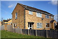
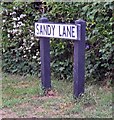
Sandy Lane, Melton Mowbray, Leics.
Both during and after WWII a thousand or more members of the tight-knit Polish community were housed in the three Nissen hut style camps for displaced Polish persons on the former Royal Air Force base in Sandy Lane. By 1955 the Council authorities had successfully expanded their stock of council houses and although by this time a small number of Polish families had obtained council houses it took many years before all the Polish families were re-housed. In 1961, when these three displaced persons’ camps were in the process of being closed down, the Melton Mowbray Polish community purchased this plot of land on which to build a their latest Polish Church and club. Although previously only open to members, in 2017 the club was rebranded, and re-registered for business purposes, as the “Goral Polish Pub” and opened to the general public. This is the view from Oxford Drive.
Image: © David Hallam-Jones
Taken: 3 Dec 2017
0.10 miles
3
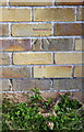
Benchmark on outbuilding at #96 Sandy Lane
Ordnance Survey cut mark benchmark described on the Bench Mark Database at http://www.bench-marks.org.uk/bm75401
Image: © Roger Templeman
Taken: 3 May 2016
0.10 miles
4
#96 and #94 Sandy Lane and #96's outbuilding
There is an OS benchmark Image on the side of the outbuilding between two sections of wooden fence
Image: © Roger Templeman
Taken: 3 May 2016
0.11 miles
5
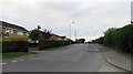
Sandy Lane into Melton Mowbray from Kirby Lane
Image: © Andrew Tatlow
Taken: 27 Apr 2020
0.11 miles
7
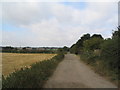
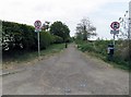
View west along Kirby Lane
This unmade road forms the southern boundary of Melton Mowbray, and may one day be superseded by a by-pass. It is a westward continuation of Sawgate Road Image
Image: © Tim Heaton
Taken: 16 Sep 2007
0.12 miles
8
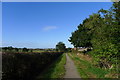
Kirby Lane, Melton Mowbray
Thought to be the line of an ancient Roman and 'saltgate' road https://www.history.ac.uk/sites/default/files/file-uploads/2019-08/vch_kirby_bellars_introduction.pdf
Also the possible future line of a Melton bypass
Image: © Tim Heaton
Taken: 30 Sep 2016
0.13 miles
9
Sandy Lane east side next to Kirby Lane
Image: © Andrew Tatlow
Taken: 27 Apr 2020
0.13 miles
10
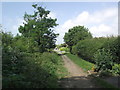
Kirby Lane
Looking towards the crossroads with Sandy Lane.
Image: © Tim Glover
Taken: 15 Jun 2020
0.13 miles