IMAGES TAKEN NEAR TO
Norfolk Drive, MELTON MOWBRAY, LE13 0AJ
Introduction
This page details the photographs taken nearby to Norfolk Drive, LE13 0AJ by members of the Geograph project.
The Geograph project started in 2005 with the aim of publishing, organising and preserving representative images for every square kilometre of Great Britain, Ireland and the Isle of Man.

There are currently over 7.5m images from over14,400 individuals and you can help contribute to the project by visiting https://www.geograph.org.uk
Image Map (Loading...)


Getting Data...Please wait
Leaflet Map data © OpenStreetMap
Images are licensed for reuse under creativecommons.org/licenses/by-sa/2.0
Notes
- Clicking on the map will re-center to the selected point.
- The higher the marker number, the further away the image location is from the centre of the postcode.
Image Listing (68 Images Found)
Images are licensed for reuse under creativecommons.org/licenses/by-sa/2.0
Image
Details
Distance
1

Path to Somerset Close from Kirby Lane
Image: © Andrew Tatlow
Taken: 27 Apr 2020
0.05 miles
2
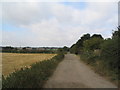
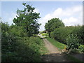
View west along Kirby Lane
This unmade road forms the southern boundary of Melton Mowbray, and may one day be superseded by a by-pass. It is a westward continuation of Sawgate Road Image
Image: © Tim Heaton
Taken: 16 Sep 2007
0.08 miles
4
Kirby Lane, Melton Mowbray
Thought to be the line of an ancient Roman and 'saltgate' road https://www.history.ac.uk/sites/default/files/file-uploads/2019-08/vch_kirby_bellars_introduction.pdf
Also the possible future line of a Melton bypass
Image: © Tim Heaton
Taken: 30 Sep 2016
0.09 miles
5
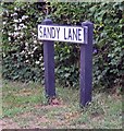
Sandy Lane into Melton Mowbray from Kirby Lane
Image: © Andrew Tatlow
Taken: 27 Apr 2020
0.10 miles
6
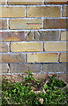
Benchmark on outbuilding at #96 Sandy Lane
Ordnance Survey cut mark benchmark described on the Bench Mark Database at http://www.bench-marks.org.uk/bm75401
Image: © Roger Templeman
Taken: 3 May 2016
0.11 miles
7
Sandy Lane east side next to Kirby Lane
Image: © Andrew Tatlow
Taken: 27 Apr 2020
0.11 miles
8
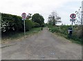
Kirby Lane
Looking towards the crossroads with Sandy Lane.
Image: © Tim Glover
Taken: 15 Jun 2020
0.11 miles
9
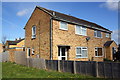
#96 and #94 Sandy Lane and #96's outbuilding
There is an OS benchmark Image on the side of the outbuilding between two sections of wooden fence
Image: © Roger Templeman
Taken: 3 May 2016
0.12 miles
10
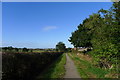
Kirby Road, Melton Road, Leics.
The residential properties that line Sandy Lane and Kirby Road give way to agricultural land here. Sandy Lane continues to the photographer's right, continuing to provide part of the National Network Route 64 between Market Harborough and Lincoln. Here however, Kirby Lane is an unmade track leading - in this direction - to the A606 road that links Melton Mowbray with Burton Lazars. Behind the photographer however, Kirby Road exists as a 'C' road heading in the direction of the A607, the road that links Rotherby with Melton Mowbray.
Image: © David Hallam-Jones
Taken: 3 Dec 2017
0.12 miles