IMAGES TAKEN NEAR TO
Charley Road, LOUGHBOROUGH, LE12 9XJ
Introduction
This page details the photographs taken nearby to Charley Road, LE12 9XJ by members of the Geograph project.
The Geograph project started in 2005 with the aim of publishing, organising and preserving representative images for every square kilometre of Great Britain, Ireland and the Isle of Man.

There are currently over 7.5m images from over14,400 individuals and you can help contribute to the project by visiting https://www.geograph.org.uk
Image Map (Loading...)


Getting Data...Please wait
Leaflet Map data © OpenStreetMap
Images are licensed for reuse under creativecommons.org/licenses/by-sa/2.0
Notes
- Clicking on the map will re-center to the selected point.
- The higher the marker number, the further away the image location is from the centre of the postcode.
Image Listing (6 Images Found)
Images are licensed for reuse under creativecommons.org/licenses/by-sa/2.0
Image
Details
Distance
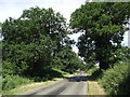
1
Charley Crossroads in Charnwood Forest
Image: © Mat Fascione
Taken: 26 May 2013
0.04 miles
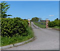
2
Bawdon Lodge Farm at Charley Crossroads
Image: © Mat Fascione
Taken: 26 May 2013
0.04 miles
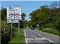
3
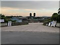
Charnwood Forrest Farm
Entrance to the farm shop
Image: © Andrew Abbott
Taken: 2 Jul 2021
0.04 miles
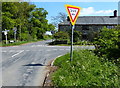
4
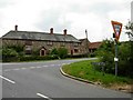
Charley Crossroads
The building is Bawdon Lodge.
Image: © Stephen McKay
Taken: 17 Jun 2006
0.07 miles