IMAGES TAKEN NEAR TO
Corcoran Close, LOUGHBOROUGH, LE12 9UT
Introduction
This page details the photographs taken nearby to Corcoran Close, LE12 9UT by members of the Geograph project.
The Geograph project started in 2005 with the aim of publishing, organising and preserving representative images for every square kilometre of Great Britain, Ireland and the Isle of Man.

There are currently over 7.5m images from over14,400 individuals and you can help contribute to the project by visiting https://www.geograph.org.uk
Image Map (Loading...)


Getting Data...Please wait
Leaflet Map data © OpenStreetMap
Images are licensed for reuse under creativecommons.org/licenses/by-sa/2.0
Notes
- Clicking on the map will re-center to the selected point.
- The higher the marker number, the further away the image location is from the centre of the postcode.
Image Listing (9 Images Found)
Images are licensed for reuse under creativecommons.org/licenses/by-sa/2.0
Image
Details
Distance
1
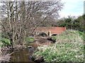
Carr Bridge
Carr Bridge carries Hallamford Road over Black Brook.
Image: © Ian Calderwood
Taken: 15 Apr 2015
0.07 miles
2
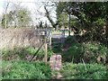
Kissing gate at Carr Bridge
The footpath beside Black Brook ends here.
Image: © Ian Calderwood
Taken: 15 Apr 2015
0.07 miles
3
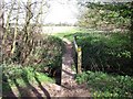
Footbridge over a drain by Black Brook
Image: © Ian Calderwood
Taken: 15 Apr 2015
0.17 miles
4
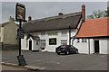
The Pied Bull, Shepshed
Unusually-named thatched pub on Belton Street.
Image: © Stephen McKay
Taken: 25 May 2007
0.18 miles
5
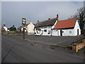
The Pied Bull, Belton Street, Shepshed
Before opening time
Image: © Tim Heaton
Taken: 22 Mar 2012
0.20 miles
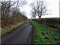
7
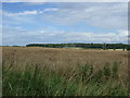
Hallamford Road/Carr Lane junction and new houses in Shepshed
Image: © Andrew Tatlow
Taken: 30 Aug 2020
0.23 miles
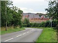
8
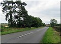
Hallamford Road southwards towards Shepshed
Image: © Andrew Tatlow
Taken: 30 Aug 2020
0.23 miles