IMAGES TAKEN NEAR TO
Celandine Road, LOUGHBOROUGH, LE12 9QT
Introduction
This page details the photographs taken nearby to Celandine Road, LE12 9QT by members of the Geograph project.
The Geograph project started in 2005 with the aim of publishing, organising and preserving representative images for every square kilometre of Great Britain, Ireland and the Isle of Man.

There are currently over 7.5m images from over14,400 individuals and you can help contribute to the project by visiting https://www.geograph.org.uk
Image Map
Images are licensed for reuse under creativecommons.org/licenses/by-sa/2.0
Notes
- Clicking on the map will re-center to the selected point.
- The higher the marker number, the further away the image location is from the centre of the postcode.
Image Listing (8 Images Found)
Images are licensed for reuse under creativecommons.org/licenses/by-sa/2.0
Image
Details
Distance
1
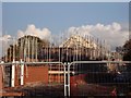
New houses under construction on Tickow Lane
Image: © Ian Calderwood
Taken: 14 Nov 2014
0.05 miles
2
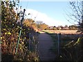
Upgraded footpath to Shepshed
Since Image was taken in 2007, the path has been widened and resurfaced.
Image: © Ian Calderwood
Taken: 14 Nov 2014
0.08 miles
5
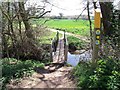
Footbridge by the ford
The bridleway from Fishpool Grange to Shepshed passes through Black Brook here but pedestrians are saved from wet feet by this bridge.
Image: © Ian Calderwood
Taken: 15 Apr 2015
0.24 miles
6
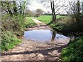
Black Brook ford
The bridleway from Fishpool Grange to Shepshed passes through Black Brook here.
Image: © Ian Calderwood
Taken: 15 Apr 2015
0.24 miles
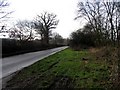
7
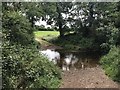
Shepshed Ford
This bridleway ford is found on the Black Brook at Shepshed.
Image: © John Walton
Taken: 16 Jun 2018
0.24 miles
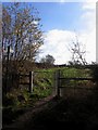
8
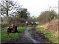
Bridleway from Tickow Lane
Black Brook at the bottom of this slope bisects the square diagonally.
Image: © Andrew Tatlow
Taken: 27 Jan 2007
0.25 miles