IMAGES TAKEN NEAR TO
Brookside Close, LOUGHBOROUGH, LE12 9HL
Introduction
This page details the photographs taken nearby to Brookside Close, LE12 9HL by members of the Geograph project.
The Geograph project started in 2005 with the aim of publishing, organising and preserving representative images for every square kilometre of Great Britain, Ireland and the Isle of Man.

There are currently over 7.5m images from over14,400 individuals and you can help contribute to the project by visiting https://www.geograph.org.uk
Image Map (Loading...)


Getting Data...Please wait
Leaflet Map data © OpenStreetMap
Images are licensed for reuse under creativecommons.org/licenses/by-sa/2.0
Notes
- Clicking on the map will re-center to the selected point.
- The higher the marker number, the further away the image location is from the centre of the postcode.
Image Listing (6 Images Found)
Images are licensed for reuse under creativecommons.org/licenses/by-sa/2.0
Image
Details
Distance
3
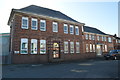
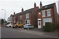
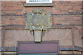
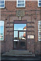
Former Drill Hall - King's Road
Now business premises for Karl Mayer Textile Machinery.
Leicestershire and Rutland design of 1913-4 with hall and indoor range to rear.
Image: © John M
Taken: 7 Mar 2014
0.21 miles
5
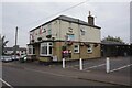
The Railway public house on Charnwood Road, Shepshed
Image: © Ian S
Taken: 27 Jul 2021
0.24 miles
6
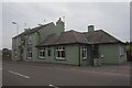
Top Railway public house on Charnwood Road, Shepshed
Image: © Ian S
Taken: 27 Jul 2021
0.24 miles