IMAGES TAKEN NEAR TO
Hathern Road, LOUGHBOROUGH, LE12 9GX
Introduction
This page details the photographs taken nearby to Hathern Road, LE12 9GX by members of the Geograph project.
The Geograph project started in 2005 with the aim of publishing, organising and preserving representative images for every square kilometre of Great Britain, Ireland and the Isle of Man.

There are currently over 7.5m images from over14,400 individuals and you can help contribute to the project by visiting https://www.geograph.org.uk
Image Map (37 Images)


Getting Data...Please wait
Leaflet Map data © OpenStreetMap
Images are licensed for reuse under creativecommons.org/licenses/by-sa/2.0
Notes
- Clicking on the map will re-center to the selected point.
- The higher the marker number, the further away the image location is from the centre of the postcode.
Image Listing (37 Images Found)
Images are licensed for reuse under creativecommons.org/licenses/by-sa/2.0
Image
Details
Distance


9
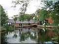
Shepshed Water Mill - millpond
Taken at the grid reference, facing north. Shepshed Water Mill has been fully restored as a working mill, and is open to the public on special days. The M1, built in the 1960s, crosses the Shepshed-Hathern road, just 200 m south of the Water Mill.
Image: © Sue Hutton
Taken: 17 Jul 2005
0.16 miles
