IMAGES TAKEN NEAR TO
Dove Close, LOUGHBOROUGH, LE12 9GE
Introduction
This page details the photographs taken nearby to Dove Close, LE12 9GE by members of the Geograph project.
The Geograph project started in 2005 with the aim of publishing, organising and preserving representative images for every square kilometre of Great Britain, Ireland and the Isle of Man.

There are currently over 7.5m images from over14,400 individuals and you can help contribute to the project by visiting https://www.geograph.org.uk
Image Map (Loading...)


Getting Data...Please wait
Leaflet Map data © OpenStreetMap
Images are licensed for reuse under creativecommons.org/licenses/by-sa/2.0
Notes
- Clicking on the map will re-center to the selected point.
- The higher the marker number, the further away the image location is from the centre of the postcode.
Image Listing (8 Images Found)
Images are licensed for reuse under creativecommons.org/licenses/by-sa/2.0
Image
Details
Distance
1
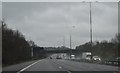
Route 6
The cycleway route 6 over the M1 near Shepshed.
Image: © John Poyser
Taken: 2 Apr 2007
0.03 miles
3

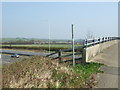
Bridge over the M1
The bridge carrying the track over the M1 at Shepshed.
Image: © John Poyser
Taken: 2 Apr 2007
0.08 miles
4
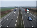
The M1, view south
From the bridge carrying Cycle Route 6 between Loughborough and Shepshed
Image: © Tim Heaton
Taken: 22 Mar 2012
0.12 miles
5
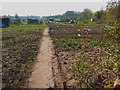
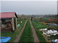
Allotments
These allotments at Shepshed are all well tended.
Image: © John Poyser
Taken: 2 Apr 2007
0.18 miles
6
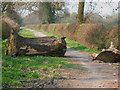
Blocked track
The old tree trunks have been placed across the track to prevent vehicular access.
Image: © John Poyser
Taken: 2 Apr 2007
0.18 miles
7
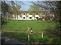
Housing estate
Part of a modern housing estate at Shepshed.
Image: © John Poyser
Taken: 2 Apr 2007
0.19 miles