IMAGES TAKEN NEAR TO
Pudding Bag Lane, LOUGHBOROUGH, LE12 9GD
Introduction
This page details the photographs taken nearby to Pudding Bag Lane, LE12 9GD by members of the Geograph project.
The Geograph project started in 2005 with the aim of publishing, organising and preserving representative images for every square kilometre of Great Britain, Ireland and the Isle of Man.

There are currently over 7.5m images from over14,400 individuals and you can help contribute to the project by visiting https://www.geograph.org.uk
Image Map (Loading...)


Getting Data...Please wait
Leaflet Map data © OpenStreetMap
Images are licensed for reuse under creativecommons.org/licenses/by-sa/2.0
Notes
- Clicking on the map will re-center to the selected point.
- The higher the marker number, the further away the image location is from the centre of the postcode.
Image Listing (17 Images Found)
Images are licensed for reuse under creativecommons.org/licenses/by-sa/2.0
Image
Details
Distance
1
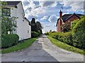
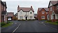
Pudding Bag Lane
An obscurely-named short length of lane that's been here since at least the late 19th century.
Image: © Ian Calderwood
Taken: 30 Apr 2024
0.01 miles
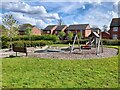
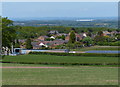
5
Monastery Gardens
A new housing development on the outskirts of Shepshed.
Image: © Peter Mackenzie
Taken: 25 Sep 2017
0.19 miles
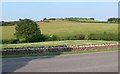
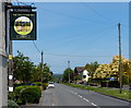
6
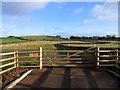
Gate and Fields
View eastwards from Charley Lane
Image: © Andrew Tatlow
Taken: 27 Jan 2007
0.20 miles
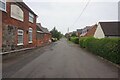
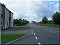
10
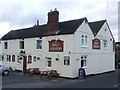
Iveshead Road in Shepshed
The sign is for The Jolly Farmers public house.
Image: © Mat Fascione
Taken: 26 May 2013
0.22 miles