IMAGES TAKEN NEAR TO
Brendon Close, LOUGHBOROUGH, LE12 9BG
Introduction
This page details the photographs taken nearby to Brendon Close, LE12 9BG by members of the Geograph project.
The Geograph project started in 2005 with the aim of publishing, organising and preserving representative images for every square kilometre of Great Britain, Ireland and the Isle of Man.

There are currently over 7.5m images from over14,400 individuals and you can help contribute to the project by visiting https://www.geograph.org.uk
Image Map
Images are licensed for reuse under creativecommons.org/licenses/by-sa/2.0
Notes
- Clicking on the map will re-center to the selected point.
- The higher the marker number, the further away the image location is from the centre of the postcode.
Image Listing (9 Images Found)
Images are licensed for reuse under creativecommons.org/licenses/by-sa/2.0
Image
Details
Distance
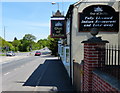
2
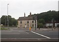
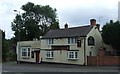
Indian restaurant and takeaway on A512
This was formerly an inn on the main road which runs south of the centre of Shepshed
Image: © David Smith
Taken: 16 Oct 2012
0.15 miles
5
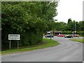
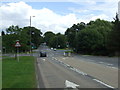
Ingleberry Road, Shepshed
Looking towards the busy A512.
Image: © Stephen McKay
Taken: 17 Jun 2006
0.17 miles
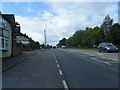
7
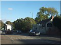
The A512 west of the M1
This road links Shepshed with the M1 motorway.
Image: © Peter Mackenzie
Taken: 25 Jun 2017
0.20 miles
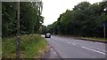
8
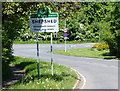
Out of India
Fully licensed Indian restaurant and takeaway, on Ashby Road Central in Shepshed.
Image: © Mat Fascione
Taken: 26 May 2013
0.20 miles