IMAGES TAKEN NEAR TO
Windmill Rise, LOUGHBOROUGH, LE12 8SG
Introduction
This page details the photographs taken nearby to Windmill Rise, LE12 8SG by members of the Geograph project.
The Geograph project started in 2005 with the aim of publishing, organising and preserving representative images for every square kilometre of Great Britain, Ireland and the Isle of Man.

There are currently over 7.5m images from over14,400 individuals and you can help contribute to the project by visiting https://www.geograph.org.uk
Image Map
Images are licensed for reuse under creativecommons.org/licenses/by-sa/2.0
Notes
- Clicking on the map will re-center to the selected point.
- The higher the marker number, the further away the image location is from the centre of the postcode.
Image Listing (35 Images Found)
Images are licensed for reuse under creativecommons.org/licenses/by-sa/2.0
Image
Details
Distance
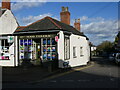
1

Shops in Woodhouse Eaves
At the left is Johnsons Traditional Butchers and on the right is Woodhouse News.
Image: © Andrew Tatlow
Taken: 4 Jun 2017
0.09 miles
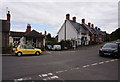
2

Woodhouse Eaves Play Area
Deserted on a cold, damp day in December
Image: © Ian Calderwood
Taken: 3 Dec 2022
0.09 miles
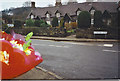
4
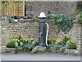
Old water pump and floral display
The display is maintained by local volunteers.
Image: © Ian Calderwood
Taken: 26 Mar 2022
0.15 miles
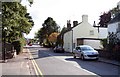
5
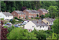
Houses on Bird Hill Road from Hill Rise
Image: © Andrew Tatlow
Taken: 4 Jun 2017
0.16 miles
6
Woodhouse Eaves
A row of stone cottages in Maplewell Road.
Image: © Colin Smith
Taken: Unknown
0.16 miles
7
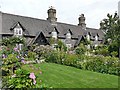
Cottages on Maplewell Road
A row of six cottages built around 1850 and grade II listed
Image: © Graham Hogg
Taken: 30 Aug 2019
0.17 miles