IMAGES TAKEN NEAR TO
Church Street, LOUGHBOROUGH, LE12 8PR
Introduction
This page details the photographs taken nearby to Church Street, LE12 8PR by members of the Geograph project.
The Geograph project started in 2005 with the aim of publishing, organising and preserving representative images for every square kilometre of Great Britain, Ireland and the Isle of Man.

There are currently over 7.5m images from over14,400 individuals and you can help contribute to the project by visiting https://www.geograph.org.uk
Image Map (Loading...)


Getting Data...Please wait
Leaflet Map data © OpenStreetMap
Images are licensed for reuse under creativecommons.org/licenses/by-sa/2.0
Notes
- Clicking on the map will re-center to the selected point.
- The higher the marker number, the further away the image location is from the centre of the postcode.
Image Listing (96 Images Found)
Images are licensed for reuse under creativecommons.org/licenses/by-sa/2.0
Image
Details
Distance
1
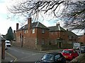
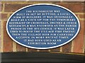
Theophilus Cave's Almshouses, 16, Church Street, Barrow-upon-Soar
Built in 1686 by Humphrey Babbington in memory of his uncle Theophilus Cave. Originally for 6 bachelors, consisting of just what is now the ground floor, in Mountsorrel granite. The upper floor was added later, probably in the early 19th century. Listed Grade II. The listing includes the gateway http://www.geograph.org.uk/photo/5296681 and wall.
Image: © Alan Murray-Rust
Taken: 24 Feb 2017
0.01 miles
2
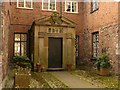
Theophilus Cave's Almshouses, 16, Church Street, Barrow-upon-Soar
The main doorway. See http://www.geograph.org.uk/photo/5296678 for location.
Image: © Alan Murray-Rust
Taken: 24 Feb 2017
0.01 miles
3
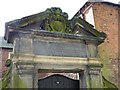
Theophilus Cave's Almshouses, 16, Church Street, Barrow-upon-Soar
Pediment over the gateway with commemorative inscription in Latin. See http://www.geograph.org.uk/photo/5296678 for location.
Image: © Alan Murray-Rust
Taken: 24 Feb 2017
0.01 miles
4
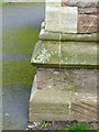
Bench mark, Holy Trinity church, Barrow-upon-Soar
On the south west corner of the tower.
Image: © Alan Murray-Rust
Taken: 24 Feb 2017
0.02 miles
5
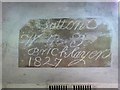
The Round House, Church Street, Barrow-upon-Soar
Commemorative plaque. See http://www.geograph.org.uk/photo/5296691 for location.
Image: © Alan Murray-Rust
Taken: 24 Feb 2017
0.02 miles
6
The Round House, Church Street, Barrow-upon-Soar
Builder's inscription on a stone inside the building http://www.geograph.org.uk/photo/5296691 .
Image: © Alan Murray-Rust
Taken: 24 Feb 2017
0.02 miles
7
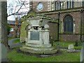
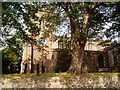
Beaumont monument, Holy Trinity churchyard, Barrow-upon-Soar
The earliest date is to Elizabeth Beaumont, d.1813, but it is more likely to have been created after the death of her husband John Storer Beaumont in 1835. An elaborate memorial for a churchyard, Listed Grade II.
Image: © Alan Murray-Rust
Taken: 24 Feb 2017
0.02 miles
8
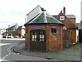
The Round House, Church Street, Barrow-upon-Soar
Built 1827 http://www.geograph.org.uk/photo/5296697 as the town lock-up and later used to house the village fire engine and hearse. See http://www.geograph.org.uk/photo/5296694. Listed Grade II.
Image: © Alan Murray-Rust
Taken: 24 Feb 2017
0.02 miles
9
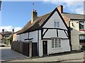
4A Beveridge Street, Barrow upon Soar
Possibly the oldest domestic building in the village. Late 16th century, timber framed, Listed Grade II.
Image: © Alan Murray-Rust
Taken: 24 Feb 2017
0.02 miles
10
Holy Trinity Church, Barrow upon Soar
Image: © Eirian Evans
Taken: 11 Sep 2006
0.02 miles