1
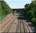
Midland Main Line at site of Barrow-on-Soar station, with DMU, 1990
View NW, towards Loughborough, Trent and the North. The original Barrow-upon-Soar station was closed 4/3/68, but a new station was opened, on the Slow lines (right hand pair), on 30/5/95 half a mile nearer London - behind the camera (see ....). The 150 class DMU is on an Up working on the Fast lines.
Image: © Ben Brooksbank
Taken: 19 Feb 1990
0.03 miles
2
Bench mark, Melton Road bridge, Barrow-upon-Soar
See http://www.geograph.org.uk/photo/5296736 for location.
Image: © Alan Murray-Rust
Taken: 24 Feb 2017
0.03 miles
3
Melton Road railway bridge, Barrow-upon-Soar
There is a bench mark http://www.geograph.org.uk/photo/5296734 on the left hand parapet by the darker brickwork to the left.
Image: © Alan Murray-Rust
Taken: 24 Feb 2017
0.03 miles
4
7 and 9 South Street and 1 Melton Road, Barrow-upon-Soar
A group of three late 18th century cottages, Listed Grade II. 1 Melton Road, to the right with the large chimney stack is Listed separately from the other pair.
Image: © Alan Murray-Rust
Taken: 24 Feb 2017
0.04 miles
5
Stable yard
These gates give entrance to a stable yard in South Street, Barrow-upon-Soar, which is a Locally Listed Building of Leicestershire County Council - see https://www.charnwood.gov.uk/listed_buildings/gates_and_stables_the_hunting_lodge_south_street_barrow_upon_soar.
The description reads "Stable Block Late C19/early C20. Local red brick on Mountsorrel granite plinth. Swithland slate pitched roofs with stone copings to gables and eaves. Attached brick gate piers with stone string course at 2/3 height surmounted by stone acorn style finial. Timber gates with inverted arched head recently replaced by crude metal gates.". By the time of my visit new timber gates had been fitted, as shown
Image: © Bob Harvey
Taken: 9 Jul 2022
0.04 miles
6
Barrow upon Soar Station
On the Ivanhoe Line. Looking towards Melton Road Bridge.
Image: © Mat Fascione
Taken: 31 Jul 2007
0.04 miles
7
Barrow upon Soar
Looking down the main street from the railway bridge.
Image: © Eirian Evans
Taken: 11 Sep 2006
0.05 miles
8
Railway
Viewed from High Street bridge looking towards Barrow upon Soar Station.
Image: © Mat Fascione
Taken: 31 Jul 2007
0.06 miles
9
Barrow-upon-Soar village sign, Melton Road
Erected for the Millennium in 2000. This side shows the bridge of the river. See http://www.geograph.org.uk/photo/5296739 for the other side.
Image: © Alan Murray-Rust
Taken: 24 Feb 2017
0.06 miles
10
Barrow-upon-Soar village sign, Melton Road
See http://www.geograph.org.uk/photo/5296738 for the complete sign. This is the reverse side showing a farrier at work.
Image: © Alan Murray-Rust
Taken: 24 Feb 2017
0.06 miles


