IMAGES TAKEN NEAR TO
Highfields, LOUGHBOROUGH, LE12 8HS
Introduction
This page details the photographs taken nearby to Highfields, LE12 8HS by members of the Geograph project.
The Geograph project started in 2005 with the aim of publishing, organising and preserving representative images for every square kilometre of Great Britain, Ireland and the Isle of Man.

There are currently over 7.5m images from over14,400 individuals and you can help contribute to the project by visiting https://www.geograph.org.uk
Image Map (Loading...)


Getting Data...Please wait
Leaflet Map data © OpenStreetMap
Images are licensed for reuse under creativecommons.org/licenses/by-sa/2.0
Notes
- Clicking on the map will re-center to the selected point.
- The higher the marker number, the further away the image location is from the centre of the postcode.
Image Listing (65 Images Found)
Images are licensed for reuse under creativecommons.org/licenses/by-sa/2.0
Image
Details
Distance
2
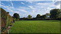
School playing fields
The local school's playing field.
Image: © Peter Mackenzie
Taken: 28 Oct 2019
0.08 miles
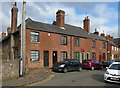
3
23-29 Church Street, Barrow-upon-Soar
Early 19th century terrace of 4 cottages, Listed Grade II.
Image: © Alan Murray-Rust
Taken: 24 Feb 2017
0.09 miles
4
3-11 Church Street, Barrow-upon-Soar
Late 18th century terrace of 5 cottages, Listed Grade II.
Image: © Alan Murray-Rust
Taken: 24 Feb 2017
0.10 miles
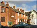
5
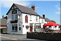
The Trap, Barrow upon Soar
Public house on North Street.
Image: © Mat Fascione
Taken: 31 Jul 2007
0.10 miles
6
13 Church Street, Barrow-upon-Soar
Dating back to the 16th or 17th century, timber frame with brick infill on partial stone plinth, Swithland slate roof, Listed Grade II.
Image: © Alan Murray-Rust
Taken: 24 Feb 2017
0.11 miles
7
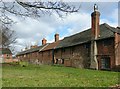
13-21 Church Street, Barrow-upon-Soar
A row of late 18th century cottages built onto an older 16th or 17th timber framed cottage (no.13). The added dwellings also include nos.3-11 http://www.geograph.org.uk/photo/5296657 of which no.3 forms the right hand end of this row. Listed Grade II.
Image: © Alan Murray-Rust
Taken: 24 Feb 2017
0.11 miles
8
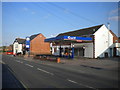
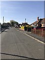
Filling station on North Street, Barrow upon Soar
Closed at about 1730 on a Saturday, despite the sign proclaiming it to be open "6.30am - 9pm 7 days".
Image: © Richard Vince
Taken: 1 Sep 2018
0.11 miles
9

North end of Breadcroft Lane, Barrow upon Soar
Seen from North Street.
Image: © Richard Vince
Taken: 1 Sep 2018
0.12 miles
10
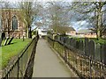
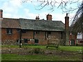
Footpath through Holy Trinity churchyard, Barrow-upon-Soar
Many of the older slate headstones have been set up alongside the path.
Image: © Alan Murray-Rust
Taken: 24 Feb 2017
0.13 miles