IMAGES TAKEN NEAR TO
Brooker Close, LOUGHBOROUGH, LE12 8GD
Introduction
This page details the photographs taken nearby to Brooker Close, LE12 8GD by members of the Geograph project.
The Geograph project started in 2005 with the aim of publishing, organising and preserving representative images for every square kilometre of Great Britain, Ireland and the Isle of Man.

There are currently over 7.5m images from over14,400 individuals and you can help contribute to the project by visiting https://www.geograph.org.uk
Image Map (Loading...)


Getting Data...Please wait
Leaflet Map data © OpenStreetMap
Images are licensed for reuse under creativecommons.org/licenses/by-sa/2.0
Notes
- Clicking on the map will re-center to the selected point.
- The higher the marker number, the further away the image location is from the centre of the postcode.
Image Listing (14 Images Found)
Images are licensed for reuse under creativecommons.org/licenses/by-sa/2.0
Image
Details
Distance
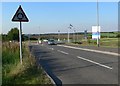

3
Catsick Hill
North of Barrow upon Soar in Leicestershire.
Image: © Mat Fascione
Taken: 4 Sep 2007
0.09 miles
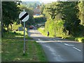
7
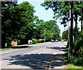
Cotes Road
Note the road runners coming towards the camera with little regard for traffic approaching from their rear.
Image: © Andrew Tatlow
Taken: 17 Jun 2006
0.13 miles
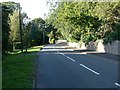
8
Stancliffe Lane
Cotes Road in the distance and a building site to the right.
Image: © Andrew Tatlow
Taken: 17 Jun 2006
0.13 miles
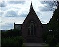
9
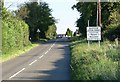
Welcome to Barrow upon Soar
Cotes Road climbs Catsick Hill.
Image: © Mat Fascione
Taken: 4 Sep 2007
0.15 miles
10
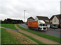
Premier Logistics on Willow Road
Image: © Andrew Tatlow
Taken: 5 Sep 2017
0.16 miles