IMAGES TAKEN NEAR TO
Soar Road, LOUGHBOROUGH, LE12 8BW
Introduction
This page details the photographs taken nearby to Soar Road, LE12 8BW by members of the Geograph project.
The Geograph project started in 2005 with the aim of publishing, organising and preserving representative images for every square kilometre of Great Britain, Ireland and the Isle of Man.

There are currently over 7.5m images from over14,400 individuals and you can help contribute to the project by visiting https://www.geograph.org.uk
Image Map (Loading...)


Getting Data...Please wait
Leaflet Map data © OpenStreetMap
Images are licensed for reuse under creativecommons.org/licenses/by-sa/2.0
Notes
- Clicking on the map will re-center to the selected point.
- The higher the marker number, the further away the image location is from the centre of the postcode.
Image Listing (38 Images Found)
Images are licensed for reuse under creativecommons.org/licenses/by-sa/2.0
Image
Details
Distance
1
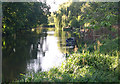
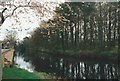
River Soar at Quorn
The river looking South from Soar Road
Image: © Bruce McKenzie
Taken: 4 Jul 2012
0.09 miles
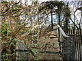
2
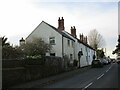
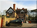
Meynell Lodge and Meynell Cottage, Quorn
Listed Grade II https://historicengland.org.uk/listing/the-list/list-entry/1230026?section=official-list-entry
Image: © Jonathan Thacker
Taken: 19 Feb 2023
0.10 miles
3
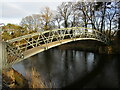
Footbridge over the River Soar at Quorn
The bridge is closed off and inaccessible.
Image: © Jonathan Thacker
Taken: 19 Feb 2023
0.10 miles
6
Disused footbridge over the River Soar, Quorn
Image: © Jonathan Thacker
Taken: 19 Feb 2023
0.10 miles